Bhag geodata
Bhag (Balochistan) is a populated place; located in Pakistan in Asia/Karachi (GMT+5) time zone. With population of 14,555 people, there are 321 cities with bigger population in this country. Compared to other cities in Pakistan, 66.4% of cities are located further ↑North; 90.7% of cities are located further →East and 68.4% of cities have higher elevation than Bhag. Note1


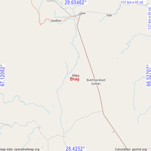
Bhag GPS coordinates[2]
29° 2' 30.264" North, 67° 49' 26.184" East
| Map corner | latitude | longitude |
|---|---|---|
| Upper-left | 29.65462°, | 67.12082° |
| Center: | 29.04174°, | 67.82394° |
| Lower-right: | 28.4252°, | 68.52707° |
| Map W x H: | 136.7×136.7 km | = 84.9×84.9mi |
| max Lat: | 36.32162° ⇑66.4% North |
| Bhag: | 29.04174° |
| min Lat: | ⇓33.6% South 24.14422° |
| min Long | Bhag | max Long |
| 61.74573° | 67.82394° | 75.63372° |
| W 9.3%⇐ | ⇒90.7% E |
Elevation
Elevation of Bhag is 103 m = 338 ft, and this is 242 m = 794 ft below average elevation for this country.
| Max E: |
2732 m = 8963 ft | 68.4% |
| Avg. | 345 m = 1132 ft | |
| Bhag | 103 m = 338 ft | |
Min E: |
3 m = 10 ft | 31.6% |
See also: Pakistan elevation on elevation.city.
Geographical zone
Bhag is located in North temperate zone (between Tropic of Cancer and the Arctic Circle). Distance of this Northern Tropic circle is 623.2 km =387.2 mi to South.| Distance of | km | miles | from Bhag |
|---|---|---|---|
| North Pole | 6777.9 | 4211.6 | to North |
| Arctic Circle | 4172 | 2592.4 | to North |
| Tropic Cancer | 623.2 | 387.2 | to South |
| Equator | 3229.1 | 2006.5 | to South |


Nearby cities:
15 places around Bhag: (largest is in red/bold)
• Chowki Jamali
114.1 km =70.9 mi,  175°
175°
• Dadhar
51 km =31.7 mi,  340°
340°
• Dera Allahyar
90.3 km =56.1 mi,  145°
145°
• Dera Murad Jamali
67.4 km =41.9 mi,  144°
144°
• Gandava
57.9 km =36 mi,  214°
214°
• Garhi Khairo
110.2 km =68.5 mi,  172°
172°
• Harnai
118.3 km =73.5 mi,  5°
5°
• Jacobabad
103.6 km =64.4 mi, 144°
• Kalat
119.6 km =74.3 mi,  269°
269°
• Mach
103.1 km =64.1 mi,  332°
332°
• Mastung
126.8 km =78.8 mi,  311°
311°
• Mehrabpur
105.7 km =65.7 mi, 169°
• Sibi
56 km =34.8 mi, 5°
• Sohbatpur
90.9 km =56.5 mi,  129°
129°
• Usta Muhammad
98.5 km =61.2 mi, 167°
Sources, notices
• [Note1] Compared only with cities in Pakistan existing in our database
• [Src1] Map data: © OpenStreetMap contributors (CC-BY-SA)
• [Src2] Other city data from geonames.org with taken over terms of usage.
• [Src3] Geographical zone / Annual Mean Temperature by Robert A. Rohde @ Wikipedia
