Khangarh geodata
Khangarh (Punjab) is a populated place; located in Pakistan in Asia/Karachi (GMT+5) time zone. With population of 19,698 people, there are 273 cities with bigger population in this country. Compared to other cities in Pakistan, 59.1% of cities are located further ↑North; 53% of cities are located further →East and 66.6% of cities have higher elevation than Khangarh. Note1


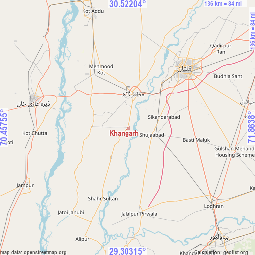
Khangarh GPS coordinates[2]
29° 54' 52.056" North, 71° 9' 38.412" East
| Map corner | latitude | longitude |
|---|---|---|
| Upper-left | 30.52204°, | 70.45755° |
| Center: | 29.91446°, | 71.16067° |
| Lower-right: | 29.30315°, | 71.8638° |
| Map W x H: | 135.5×135.5 km | = 84.2×84.2mi |
| max Lat: | 36.32162° ⇑59.1% North |
| Khangarh: | 29.91446° |
| min Lat: | ⇓40.9% South 24.14422° |
| min Long | Khangarh | max Long |
| 61.74573° | 71.16067° | 75.63372° |
| W 47%⇐ | ⇒53% E |
Elevation
Elevation of Khangarh is 120 m = 394 ft, and this is 225 m = 738 ft below average elevation for this country.
| Max E: |
2732 m = 8963 ft | 66.6% |
| Avg. | 345 m = 1132 ft | |
| Khangarh | 120 m = 394 ft | |
Min E: |
3 m = 10 ft | 33.4% |
See also: Pakistan elevation on elevation.city.
Geographical zone
Khangarh is located in North temperate zone (between Tropic of Cancer and the Arctic Circle). Distance of this Northern Tropic circle is 720.3 km =447.6 mi to South.| Distance of | km | miles | from Khangarh |
|---|---|---|---|
| North Pole | 6680.9 | 4151.3 | to North |
| Arctic Circle | 4075 | 2532.1 | to North |
| Tropic Cancer | 720.3 | 447.6 | to South |
| Equator | 3326.2 | 2066.8 | to South |


Nearby cities:
15 places around Khangarh: (largest is in red/bold)
• Alipur
63.9 km =39.7 mi,  202°
202°
• Bahawalpur
76 km =47.2 mi,  139°
139°
• Dera Ghazi Khan
52.2 km =32.4 mi,  286°
286°
• Dhanot
68.1 km =42.3 mi,  123°
123°
• Dunyapur
57.6 km =35.8 mi,  102°
102°
• Jalalpur Pirwala
45.9 km =28.5 mi,  172°
172°
• Jampur
62.4 km =38.8 mi,  240°
240°
• Jatoi Shimali
53.6 km =33.3 mi,  214°
214°
• Kot Addu
64.4 km =40 mi,  343°
343°
• Lodhran
62.2 km =38.6 mi,  132°
132°
• Multan
43.8 km =27.2 mi,  44°
44°
• Muzaffargarh
17.9 km =11.1 mi,  10°
10°
• Qadirpur Ran
64.6 km =40.1 mi,  49°
49°
• Shahr Sultan
40 km =24.9 mi, 199°
• Shujaabad
13.3 km =8.3 mi,  106°
106°
Sources, notices
• [Note1] Compared only with cities in Pakistan existing in our database
• [Src1] Map data: © OpenStreetMap contributors (CC-BY-SA)
• [Src2] Other city data from geonames.org with taken over terms of usage.
• [Src3] Geographical zone / Annual Mean Temperature by Robert A. Rohde @ Wikipedia
