Gojra geodata
Gojra (Punjab) is a populated place; located in Pakistan in Asia/Karachi (GMT+5) time zone. With population of 139,726 people, there are 47 cities with bigger population in this country. Compared to other cities in Pakistan, 55.1% of cities are located further ↓South; 67.7% of cities are located further ←West and 53.5% of cities have higher elevation than Gojra. Note1


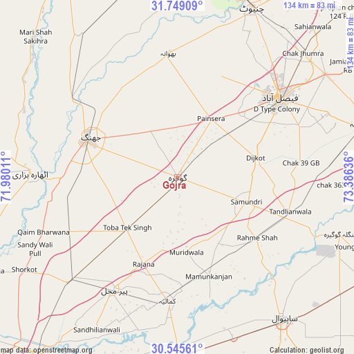
Gojra GPS coordinates[2]
31° 8' 57.336" North, 72° 40' 59.628" East
| Map corner | latitude | longitude |
|---|---|---|
| Upper-left | 31.74909°, | 71.98011° |
| Center: | 31.14926°, | 72.68323° |
| Lower-right: | 30.54561°, | 73.38636° |
| Map W x H: | 133.8×133.8 km | = 83.1×83.1mi |
| max Lat: | 36.32162° ⇑44.9% North |
| Gojra: | 31.14926° |
| min Lat: | ⇓55.1% South 24.14422° |
| min Long | Gojra | max Long |
| 61.74573° | 72.68323° | 75.63372° |
| W 67.7%⇐ | ⇒32.3% E |
Elevation
Elevation of Gojra is 169 m = 554 ft, and this is 176 m = 577 ft below average elevation for this country.
| Max E: |
2732 m = 8963 ft | 53.5% |
| Avg. | 345 m = 1132 ft | |
| Gojra | 169 m = 554 ft | |
Min E: |
3 m = 10 ft | 46.5% |
See also: Gojra elevation on elevation.city.
Geographical zone
Gojra is located in North temperate zone (between Tropic of Cancer and the Arctic Circle). Distance of this Northern Tropic circle is 857.6 km =532.9 mi to South.| Distance of | km | miles | from Gojra |
|---|---|---|---|
| North Pole | 6543.6 | 4066 | to North |
| Arctic Circle | 3937.7 | 2446.8 | to North |
| Tropic Cancer | 857.6 | 532.9 | to South |
| Equator | 3463.5 | 2152.1 | to South |


Nearby cities:
15 places around Gojra: (largest is in red/bold)
• Bhawana
46.8 km =29.1 mi,  356°
356°
• Chak Azam Sahu
55.1 km =34.2 mi,  143°
143°
• Chak Jhumra
66.5 km =41.3 mi,  45°
45°
• Chichawatni
68.8 km =42.8 mi,  179°
179°
• Dijkot
30.7 km =19.1 mi,  75°
75°
• Faisalabad
48.7 km =30.3 mi, 52°
• Jhang City
38.2 km =23.7 mi,  297°
297°
• Jhang Sadr
37.3 km =23.2 mi,  291°
291°
• Kamalia
47.1 km =29.3 mi, 184°
• Khurrianwala
67.8 km =42.1 mi, 54°
• Mamu Kanjan
37.1 km =23.1 mi,  162°
162°
• Pir Mahal
48.7 km =30.3 mi,  209°
209°
• Sahiwal
67 km =41.6 mi, 143°
• Tandlianwala
44.7 km =27.8 mi,  106°
106°
• Toba Tek Singh
27.5 km =17.1 mi,  223°
223°
Sources, notices
• [Note1] Compared only with cities in Pakistan existing in our database
• [Src1] Map data: © OpenStreetMap contributors (CC-BY-SA)
• [Src2] Other city data from geonames.org with taken over terms of usage.
• [Src3] Geographical zone / Annual Mean Temperature by Robert A. Rohde @ Wikipedia
