Jhang City geodata
Jhang City (Punjab) is a seat of a second-order administrative division; located in Pakistan in Asia/Karachi (GMT+5) time zone. In our database, there are 416 cities with bigger population. Compared to other cities in Pakistan, 57.1% of cities are located further ↓South; 60.9% of cities are located further ←West and 56.7% of cities have higher elevation than Jhang City. Note1


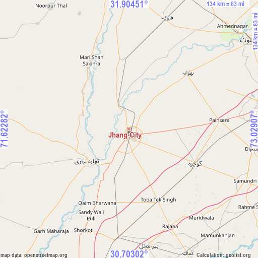
Jhang City GPS coordinates[2]
31° 18' 20.448" North, 72° 19' 33.384" East
| Map corner | latitude | longitude |
|---|---|---|
| Upper-left | 31.90451°, | 71.62282° |
| Center: | 31.30568°, | 72.32594° |
| Lower-right: | 30.70302°, | 73.02907° |
| Map W x H: | 133.6×133.6 km | = 83×83mi |
| max Lat: | 36.32162° ⇑42.9% North |
| Jhang City: | 31.30568° |
| min Lat: | ⇓57.1% South 24.14422° |
| min Long | Jhang City | max Long |
| 61.74573° | 72.32594° | 75.63372° |
| W 60.9%⇐ | ⇒39.1% E |
Elevation
Elevation of Jhang City is 160 m = 525 ft, and this is 185 m = 607 ft below average elevation for this country.
| Max E: |
2732 m = 8963 ft | 56.7% |
| Avg. | 345 m = 1132 ft | |
| Jhang City | 160 m = 525 ft | |
Min E: |
3 m = 10 ft | 43.3% |
See also: Pakistan elevation on elevation.city.
Geographical zone
Jhang City is located in North temperate zone (between Tropic of Cancer and the Arctic Circle). Distance of this Northern Tropic circle is 874.9 km =543.6 mi to South.| Distance of | km | miles | from Jhang City |
|---|---|---|---|
| North Pole | 6526.2 | 4055.2 | to North |
| Arctic Circle | 3920.3 | 2436 | to North |
| Tropic Cancer | 874.9 | 543.6 | to South |
| Equator | 3480.9 | 2162.9 | to South |


Nearby cities:
15 places around Jhang City: (largest is in red/bold)
• Bhawana
42.4 km =26.3 mi,  46°
46°
• Dijkot
64.5 km =40.1 mi,  98°
98°
• Faisalabad
73.5 km =45.7 mi,  80°
80°
• Faruka
65.1 km =40.5 mi,  7°
7°
• Garh Maharaja
66 km =41 mi,  217°
217°
• Gojra
38.2 km =23.7 mi,  117°
117°
• Jahanian Shah
55.8 km =34.7 mi,  355°
355°
• Jhang Sadr
4.1 km =2.5 mi,  192°
192°
• Kamalia
71.2 km =44.2 mi,  154°
154°
• Lalian
73.2 km =45.5 mi,  37°
37°
• Mamu Kanjan
69.5 km =43.2 mi,  139°
139°
• Mangla
65.5 km =40.7 mi,  4°
4°
• Pir Mahal
60.8 km =37.8 mi,  170°
170°
• Sillanwali
61.3 km =38.1 mi,  19°
19°
• Toba Tek Singh
40.1 km =24.9 mi,  158°
158°
Sources, notices
• [Note1] Compared only with cities in Pakistan existing in our database
• [Src1] Map data: © OpenStreetMap contributors (CC-BY-SA)
• [Src2] Other city data from geonames.org with taken over terms of usage.
• [Src3] Geographical zone / Annual Mean Temperature by Robert A. Rohde @ Wikipedia
