Żychlin geodata
Żychlin (Łódź Voivodeship) is a seat of a third-order administrative division; located in Poland in Europe/Warsaw (GMT+2) time zone. With population of 9,009 people, there are 479 cities with bigger population in this country. Compared to other cities in Poland, 71.2% of cities are located further ↓South; 51.4% of cities are located further ←West and 79.8% of cities have higher elevation than Żychlin. Note1


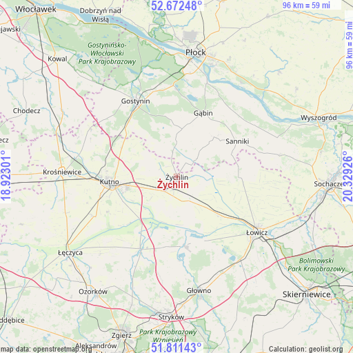
Żychlin GPS coordinates[2]
52° 14' 38.544" North, 19° 37' 34.068" East
| Map corner | latitude | longitude |
|---|---|---|
| Upper-left | 52.67248°, | 18.92301° |
| Center: | 52.24404°, | 19.62613° |
| Lower-right: | 51.81143°, | 20.32926° |
| Map W x H: | 95.7×95.7 km | = 59.5×59.5mi |
| max Lat: | 54.83135° ⇑28.8% North |
| Żychlin: | 52.24404° |
| min Lat: | ⇓71.2% South 49.21328° |
| min Long | Żychlin | max Long |
| 14.20249° | 19.62613° | 24.03723° |
| W 51.4%⇐ | ⇒48.6% E |
Elevation
Elevation of Żychlin is 100 m = 328 ft, and this is 91.4 m = 300 ft below average elevation for this country.
| Max E: |
974 m = 3196 ft | 79.8% |
| Avg. | 191.4 m = 628 ft | |
| Żychlin | 100 m = 328 ft | |
Min E: |
-3 m = -10 ft | 20.2% |
See also: Poland elevation on elevation.city.
Geographical zone
Żychlin is located in North temperate zone (between Tropic of Cancer and the Arctic Circle). Distance of this North polar circle is 1592.2 km =989.3 mi to North.| Distance of | km | miles | from Żychlin |
|---|---|---|---|
| North Pole | 4198.1 | 2608.6 | to North |
| Arctic Circle | 1592.2 | 989.3 | to North |
| Tropic Cancer | 3203.1 | 1990.3 | to South |
| Equator | 5809 | 3609.5 | to South |


Nearby cities:
15 places around Żychlin: (largest is in red/bold)
• Bedlno
5.2 km =3.2 mi,  220°
220°
• Bielawy
18.9 km =11.7 mi,  173°
173°
• Chąśno
22.2 km =13.8 mi,  104°
104°
• Gąbin
18.7 km =11.6 mi,  23°
23°
• Kiernozia
16.9 km =10.5 mi,  80°
80°
• Krzyżanów
13.4 km =8.3 mi,  240°
240°
• Kutno
17.9 km =11.1 mi,  265°
265°
• Nowe Zduny
16.7 km =10.4 mi,  131°
131°
• Oporów
4.8 km =3 mi,  298°
298°
• Pacyna
8.7 km =5.4 mi,  41°
41°
• Piątek
21.9 km =13.6 mi,  207°
207°
• Sanniki
19 km =11.8 mi,  59°
59°
• Stary Barcik
20.7 km =12.9 mi, 43°
• Strzelce
16.9 km =10.5 mi, 297°
• Zduny
16.2 km =10.1 mi, 127°
Sources, notices
• [Note1] Compared only with cities in Poland existing in our database
• [Src1] Map data: © OpenStreetMap contributors (CC-BY-SA)
• [Src2] Other city data from geonames.org with taken over terms of usage.
• [Src3] Geographical zone / Annual Mean Temperature by Robert A. Rohde @ Wikipedia
