Kutno geodata
Kutno (Łódź Voivodeship) is a seat of a second-order administrative division; located in Poland in Europe/Warsaw (GMT+2) time zone. With population of 48,323 people, there are 106 cities with bigger population in this country. Compared to other cities in Poland, 70.9% of cities are located further ↓South; 53.3% of cities are located further →East and 74.5% of cities have higher elevation than Kutno. Note1


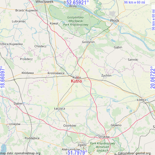
Kutno GPS coordinates[2]
52° 13' 50.304" North, 19° 21' 50.724" East
| Map corner | latitude | longitude |
|---|---|---|
| Upper-left | 52.65921°, | 18.66097° |
| Center: | 52.23064°, | 19.36409° |
| Lower-right: | 51.7979°, | 20.06722° |
| Map W x H: | 95.8×95.8 km | = 59.5×59.5mi |
| max Lat: | 54.83135° ⇑29.1% North |
| Kutno: | 52.23064° |
| min Lat: | ⇓70.9% South 49.21328° |
| min Long | Kutno | max Long |
| 14.20249° | 19.36409° | 24.03723° |
| W 46.7%⇐ | ⇒53.3% E |
Elevation
Elevation of Kutno is 112 m = 367 ft, and this is 79.4 m = 260 ft below average elevation for this country.
| Max E: |
974 m = 3196 ft | 74.5% |
| Avg. | 191.4 m = 628 ft | |
| Kutno | 112 m = 367 ft | |
Min E: |
-3 m = -10 ft | 25.5% |
See also: Kutno elevation on elevation.city.
Geographical zone
Kutno is located in North temperate zone (between Tropic of Cancer and the Arctic Circle). Distance of this North polar circle is 1593.7 km =990.3 mi to North.| Distance of | km | miles | from Kutno |
|---|---|---|---|
| North Pole | 4199.6 | 2609.5 | to North |
| Arctic Circle | 1593.7 | 990.3 | to North |
| Tropic Cancer | 3201.6 | 1989.4 | to South |
| Equator | 5807.5 | 3608.6 | to South |


Nearby cities:
15 places around Kutno: (largest is in red/bold)
• Bedlno
14.6 km =9.1 mi,  99°
99°
• Daszyna
15 km =9.3 mi,  235°
235°
• Dąbrowice
21 km =13 mi,  295°
295°
• Góra Świętej Małgorzaty
19.5 km =12.1 mi,  188°
188°
• Krośniewice
13.5 km =8.4 mi,  282°
282°
• Krzyżanów
8.1 km =5 mi,  129°
129°
• Nowe Ostrowy
14.2 km =8.8 mi, 304°
• Oporów
14.1 km =8.8 mi,  74°
74°
• Ostrowy
15.8 km =9.8 mi, 301°
• Piątek
19.6 km =12.2 mi,  156°
156°
• Strzelce
9.8 km =6.1 mi,  17°
17°
• Witonia
10.3 km =6.4 mi,  204°
204°
• Łanięta
15.7 km =9.8 mi,  338°
338°
• Łęczyca
22.1 km =13.7 mi,  210°
210°
• Żychlin
17.9 km =11.1 mi,  85°
85°
Sources, notices
• [Note1] Compared only with cities in Poland existing in our database
• [Src1] Map data: © OpenStreetMap contributors (CC-BY-SA)
• [Src2] Other city data from geonames.org with taken over terms of usage.
• [Src3] Geographical zone / Annual Mean Temperature by Robert A. Rohde @ Wikipedia
