Sanniki geodata
Sanniki (Mazovia) is a seat of a third-order administrative division; located in Poland in Europe/Warsaw (GMT+2) time zone. With population of 2,000 people, there are 1469 cities with bigger population in this country. Compared to other cities in Poland, 73.2% of cities are located further ↓South; 56.2% of cities are located further ←West and 76.4% of cities have higher elevation than Sanniki. Note1


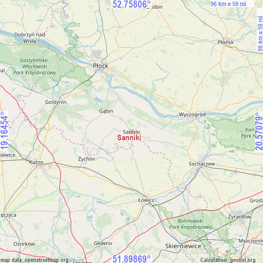
Sanniki GPS coordinates[2]
52° 19' 49.656" North, 19° 52' 3.576" East
| Map corner | latitude | longitude |
|---|---|---|
| Upper-left | 52.75806°, | 19.16454° |
| Center: | 52.33046°, | 19.86766° |
| Lower-right: | 51.89869°, | 20.57079° |
| Map W x H: | 95.6×95.6 km | = 59.4×59.4mi |
| max Lat: | 54.83135° ⇑26.8% North |
| Sanniki: | 52.33046° |
| min Lat: | ⇓73.2% South 49.21328° |
| min Long | Sanniki | max Long |
| 14.20249° | 19.86766° | 24.03723° |
| W 56.2%⇐ | ⇒43.8% E |
Elevation
Elevation of Sanniki is 107 m = 351 ft, and this is 84.4 m = 277 ft below average elevation for this country.
| Max E: |
974 m = 3196 ft | 76.4% |
| Avg. | 191.4 m = 628 ft | |
| Sanniki | 107 m = 351 ft | |
Min E: |
-3 m = -10 ft | 23.6% |
See also: Poland elevation on elevation.city.
Geographical zone
Sanniki is located in North temperate zone (between Tropic of Cancer and the Arctic Circle). Distance of this North polar circle is 1582.6 km =983.4 mi to North.| Distance of | km | miles | from Sanniki |
|---|---|---|---|
| North Pole | 4188.5 | 2602.6 | to North |
| Arctic Circle | 1582.6 | 983.4 | to North |
| Tropic Cancer | 3212.7 | 1996.3 | to South |
| Equator | 5818.6 | 3615.5 | to South |


Nearby cities:
15 places around Sanniki: (largest is in red/bold)
• Chąśno
15.9 km =9.9 mi,  161°
161°
• Gąbin
11.8 km =7.3 mi,  310°
310°
• Iłów
10.9 km =6.8 mi,  84°
84°
• Kiernozia
6.9 km =4.3 mi,  178°
178°
• Kocierzew Południowy
16.2 km =10.1 mi,  140°
140°
• Mała Wieś
21.3 km =13.2 mi,  48°
48°
• Nowe Zduny
21.1 km =13.1 mi,  191°
191°
• Pacyna
11.2 km =7 mi,  254°
254°
• Rybno
18.7 km =11.6 mi,  121°
121°
• Stary Barcik
5.9 km =3.7 mi,  337°
337°
• Słubice
6.5 km =4 mi, 48°
• Słupno
19.6 km =12.2 mi,  353°
353°
• Zduny
19.7 km =12.2 mi, 190°
• Łaziska
5.1 km =3.2 mi,  8°
8°
• Żychlin
19 km =11.8 mi,  239°
239°
Sources, notices
• [Note1] Compared only with cities in Poland existing in our database
• [Src1] Map data: © OpenStreetMap contributors (CC-BY-SA)
• [Src2] Other city data from geonames.org with taken over terms of usage.
• [Src3] Geographical zone / Annual Mean Temperature by Robert A. Rohde @ Wikipedia
