Pacyna geodata
Pacyna (Mazovia) is a seat of a third-order administrative division; located in Poland in Europe/Warsaw (GMT+2) time zone. With population of 219 people, there are 3641 cities with bigger population in this country. Compared to other cities in Poland, 72.5% of cities are located further ↓South; 52.9% of cities are located further ←West and 80.2% of cities have higher elevation than Pacyna. Note1


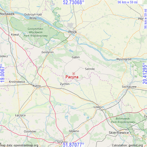
Pacyna GPS coordinates[2]
52° 18' 10.116" North, 19° 42' 35.352" East
| Map corner | latitude | longitude |
|---|---|---|
| Upper-left | 52.73068°, | 19.0067° |
| Center: | 52.30281°, | 19.70982° |
| Lower-right: | 51.87077°, | 20.41295° |
| Map W x H: | 95.6×95.6 km | = 59.4×59.4mi |
| max Lat: | 54.83135° ⇑27.5% North |
| Pacyna: | 52.30281° |
| min Lat: | ⇓72.5% South 49.21328° |
| min Long | Pacyna | max Long |
| 14.20249° | 19.70982° | 24.03723° |
| W 52.9%⇐ | ⇒47.1% E |
Elevation
Elevation of Pacyna is 99 m = 325 ft, and this is 92.4 m = 303 ft below average elevation for this country.
| Max E: |
974 m = 3196 ft | 80.2% |
| Avg. | 191.4 m = 628 ft | |
| Pacyna | 99 m = 325 ft | |
Min E: |
-3 m = -10 ft | 19.8% |
See also: Poland elevation on elevation.city.
Geographical zone
Pacyna is located in North temperate zone (between Tropic of Cancer and the Arctic Circle). Distance of this North polar circle is 1585.6 km =985.2 mi to North.| Distance of | km | miles | from Pacyna |
|---|---|---|---|
| North Pole | 4191.5 | 2604.5 | to North |
| Arctic Circle | 1585.6 | 985.2 | to North |
| Tropic Cancer | 3209.6 | 1994.4 | to South |
| Equator | 5815.5 | 3613.6 | to South |


Nearby cities:
15 places around Pacyna: (largest is in red/bold)
• Bedlno
13.9 km =8.6 mi,  220°
220°
• Chąśno
19.8 km =12.3 mi,  127°
127°
• Gąbin
10.8 km =6.7 mi,  9°
9°
• Kiernozia
11.6 km =7.2 mi,  109°
109°
• Krzyżanów
21.7 km =13.5 mi,  232°
232°
• Nowe Zduny
18.9 km =11.7 mi,  159°
159°
• Oporów
10.8 km =6.7 mi,  246°
246°
• Sanniki
11.2 km =7 mi,  74°
74°
• Stary Barcik
12 km =7.5 mi,  44°
44°
• Strzelce
20.6 km =12.8 mi,  273°
273°
• Słubice
17.2 km =10.7 mi,  64°
64°
• Zduny
17.9 km =11.1 mi, 156°
• Łaziska
14.1 km =8.8 mi,  54°
54°
• Łąck
19.4 km =12.1 mi,  339°
339°
• Żychlin
8.7 km =5.4 mi, 221°
Sources, notices
• [Note1] Compared only with cities in Poland existing in our database
• [Src1] Map data: © OpenStreetMap contributors (CC-BY-SA)
• [Src2] Other city data from geonames.org with taken over terms of usage.
• [Src3] Geographical zone / Annual Mean Temperature by Robert A. Rohde @ Wikipedia
