Kiernozia geodata
Kiernozia (Łódź Voivodeship) is a seat of a third-order administrative division; located in Poland in Europe/Warsaw (GMT+2) time zone. With population of 930 people, there are 2620 cities with bigger population in this country. Compared to other cities in Poland, 71.9% of cities are located further ↓South; 56.2% of cities are located further ←West and 78.8% of cities have higher elevation than Kiernozia. Note1


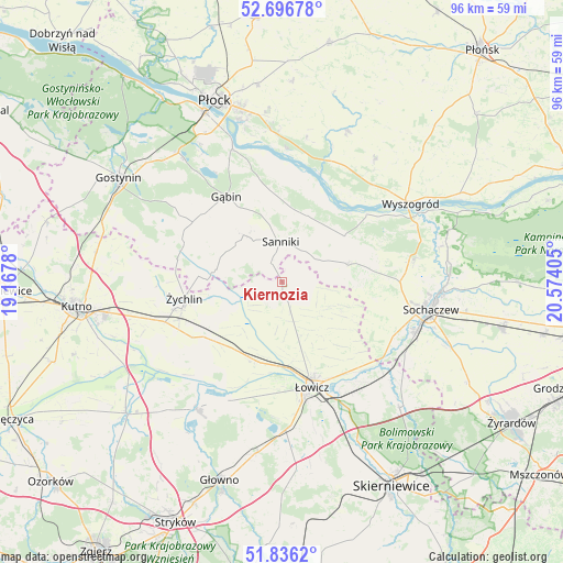
Kiernozia GPS coordinates[2]
52° 16' 6.888" North, 19° 52' 15.312" East
| Map corner | latitude | longitude |
|---|---|---|
| Upper-left | 52.69678°, | 19.1678° |
| Center: | 52.26858°, | 19.87092° |
| Lower-right: | 51.8362°, | 20.57405° |
| Map W x H: | 95.7×95.7 km | = 59.5×59.5mi |
| max Lat: | 54.83135° ⇑28.1% North |
| Kiernozia: | 52.26858° |
| min Lat: | ⇓71.9% South 49.21328° |
| min Long | Kiernozia | max Long |
| 14.20249° | 19.87092° | 24.03723° |
| W 56.2%⇐ | ⇒43.8% E |
Elevation
Elevation of Kiernozia is 102 m = 335 ft, and this is 89.4 m = 293 ft below average elevation for this country.
| Max E: |
974 m = 3196 ft | 78.8% |
| Avg. | 191.4 m = 628 ft | |
| Kiernozia | 102 m = 335 ft | |
Min E: |
-3 m = -10 ft | 21.2% |
See also: Poland elevation on elevation.city.
Geographical zone
Kiernozia is located in North temperate zone (between Tropic of Cancer and the Arctic Circle). Distance of this North polar circle is 1589.5 km =987.7 mi to North.| Distance of | km | miles | from Kiernozia |
|---|---|---|---|
| North Pole | 4195.3 | 2606.8 | to North |
| Arctic Circle | 1589.5 | 987.7 | to North |
| Tropic Cancer | 3205.8 | 1992 | to South |
| Equator | 5811.7 | 3611.2 | to South |


Nearby cities:
15 places around Kiernozia: (largest is in red/bold)
• Chąśno
9.5 km =5.9 mi,  149°
149°
• Gąbin
17.1 km =10.6 mi,  327°
327°
• Iłów
13.2 km =8.2 mi,  53°
53°
• Kocierzew Południowy
11.5 km =7.1 mi,  119°
119°
• Nowe Zduny
14.5 km =9 mi,  197°
197°
• Oporów
20.9 km =13 mi,  268°
268°
• Pacyna
11.6 km =7.2 mi,  289°
289°
• Rybno
16.1 km =10 mi,  100°
100°
• Sanniki
6.9 km =4.3 mi,  358°
358°
• Stary Barcik
12.6 km =7.8 mi,  348°
348°
• Słubice
12.1 km =7.5 mi,  22°
22°
• Zduny
13.1 km =8.1 mi, 196°
• Łaziska
12 km =7.5 mi,  2°
2°
• Łowicz
18.7 km =11.6 mi,  164°
164°
• Żychlin
16.9 km =10.5 mi,  260°
260°
Sources, notices
• [Note1] Compared only with cities in Poland existing in our database
• [Src1] Map data: © OpenStreetMap contributors (CC-BY-SA)
• [Src2] Other city data from geonames.org with taken over terms of usage.
• [Src3] Geographical zone / Annual Mean Temperature by Robert A. Rohde @ Wikipedia
