Tarnów geodata
Tarnów (Lower Silesia) is a populated place; located in Poland in Europe/Warsaw (GMT+2) time zone. With population of 566 people, there are 3368 cities with bigger population in this country. Compared to other cities in Poland, 65.7% of cities are located further ↑North; 87.4% of cities are located further →East and 85.6% of cities have lower elevation than Tarnów. Note1
Administrative division(s):
- Level 1: Lower Silesia
- Level 2: Powiat ząbkowicki
- Level 3: Ząbkowice Śląskie


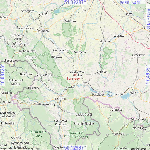
Tarnów GPS coordinates[2]
50° 34' 42.564" North, 16° 47' 25.332" East
| Map corner | latitude | longitude |
|---|---|---|
| Upper-left | 51.02287°, | 16.08725° |
| Center: | 50.57849°, | 16.79037° |
| Lower-right: | 50.12987°, | 17.4935° |
| Map W x H: | 99.3×99.3 km | = 61.7×61.7mi |
| max Lat: | 54.83135° ⇑65.7% North |
| Tarnów: | 50.57849° |
| min Lat: | ⇓34.3% South 49.21328° |
| min Long | Tarnów | max Long |
| 14.20249° | 16.79037° | 24.03723° |
| W 12.6%⇐ | ⇒87.4% E |
Elevation
Elevation of Tarnów is 293 m = 961 ft, and this is 101.6 m = 333 ft above average elevation for this country.
| Max E: |
974 m = 3196 ft | 14.4% |
| Tarnów | 293 m 961 ft | |
| Avg. | 191.4 m = 628 ft | |
Min E: |
-3 m = -10 ft | 85.6% |
See also: Poland elevation on elevation.city.
Geographical zone
Tarnów is located in North temperate zone (between Tropic of Cancer and the Arctic Circle). Distance of this North polar circle is 1777.4 km =1104.4 mi to North.| Distance of | km | miles | from Tarnów |
|---|---|---|---|
| North Pole | 4383.3 | 2723.7 | to North |
| Arctic Circle | 1777.4 | 1104.4 | to North |
| Tropic Cancer | 3017.9 | 1875.2 | to South |
| Equator | 5623.8 | 3494.5 | to South |


Nearby cities:
15 places around Tarnów: (largest is in red/bold)
• Bardo
8.8 km =5.5 mi,  203°
203°
• Bobolice
6.9 km =4.3 mi,  44°
44°
• Brzeźnica
5.9 km =3.7 mi,  223°
223°
• Budzów
5.9 km =3.7 mi,  286°
286°
• Ciepłowody
13.6 km =8.5 mi, 37°
• Jodłownik
14.6 km =9.1 mi,  300°
300°
• Kamieniec Ząbkowicki
8.6 km =5.3 mi,  133°
133°
• Niedźwiedź
15.6 km =9.7 mi,  106°
106°
• Niemcza
16.1 km =10 mi,  11°
11°
• Ostroszowice
13 km =8.1 mi,  305°
305°
• Piława Górna
12.1 km =7.5 mi,  344°
344°
• Przyłęk
6.6 km =4.1 mi,  187°
187°
• Stoszowice
4.3 km =2.7 mi, 303°
• Wojciechowice
15.1 km =9.4 mi, 203°
• Ząbkowice Śląskie
2 km =1.2 mi,  51°
51°
Sources, notices
• [Note1] Compared only with cities in Poland existing in our database
• [Src1] Map data: © OpenStreetMap contributors (CC-BY-SA)
• [Src2] Other city data from geonames.org with taken over terms of usage.
• [Src3] Geographical zone / Annual Mean Temperature by Robert A. Rohde @ Wikipedia
