Miłoradz geodata
Miłoradz (Pomerania) is a populated place; located in Poland in Europe/Warsaw (GMT+2) time zone. With population of 1,114 people, there are 2289 cities with bigger population in this country. Compared to other cities in Poland, 94.4% of cities are located further ↓South; 61.6% of cities are located further →East and 98.9% of cities have higher elevation than Miłoradz. Note1


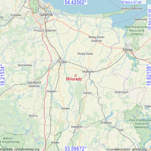
Miłoradz GPS coordinates[2]
54° 0' 50.112" North, 18° 55' 6.456" East
| Map corner | latitude | longitude |
|---|---|---|
| Upper-left | 54.42502°, | 18.21534° |
| Center: | 54.01392°, | 18.91846° |
| Lower-right: | 53.59872°, | 19.62159° |
| Map W x H: | 91.9×91.9 km | = 57.1×57.1mi |
| max Lat: | 54.83135° ⇑5.6% North |
| Miłoradz: | 54.01392° |
| min Lat: | ⇓94.4% South 49.21328° |
| min Long | Miłoradz | max Long |
| 14.20249° | 18.91846° | 24.03723° |
| W 38.4%⇐ | ⇒61.6% E |
Elevation
Elevation of Miłoradz is 5 m = 16 ft, and this is 186.4 m = 612 ft below average elevation for this country.
| Max E: |
974 m = 3196 ft | 98.9% |
| Avg. | 191.4 m = 628 ft | |
| Miłoradz | 5 m = 16 ft | |
Min E: |
-3 m = -10 ft | 1.1% |
See also: Poland elevation on elevation.city.
Geographical zone
Miłoradz is located in North temperate zone (between Tropic of Cancer and the Arctic Circle). Distance of this North polar circle is 1395.4 km =867.1 mi to North.| Distance of | km | miles | from Miłoradz |
|---|---|---|---|
| North Pole | 4001.3 | 2486.3 | to North |
| Arctic Circle | 1395.4 | 867.1 | to North |
| Tropic Cancer | 3399.9 | 2112.6 | to South |
| Equator | 6005.8 | 3731.8 | to South |


Nearby cities:
15 places around Miłoradz: (largest is in red/bold)
• Czarlin
11.1 km =6.9 mi,  292°
292°
• Gniew
20.7 km =12.9 mi,  197°
197°
• Lichnowy
11.3 km =7 mi,  358°
358°
• Lisewo Malborskie
10.9 km =6.8 mi,  327°
327°
• Malbork
7.5 km =4.7 mi,  70°
70°
• Nowy Staw
14.8 km =9.2 mi,  23°
23°
• Pelplin
17.3 km =10.7 mi,  236°
236°
• Ryjewo
19 km =11.8 mi,  171°
171°
• Stare Pole
19.5 km =12.1 mi,  75°
75°
• Stary Targ
19.3 km =12 mi,  121°
121°
• Subkowy
9.8 km =6.1 mi,  262°
262°
• Sztum
12.7 km =7.9 mi,  144°
144°
• Tczew
12.7 km =7.9 mi,  313°
313°
• Wielkie Walichnowy
11.6 km =7.2 mi, 201°
• Zduny
19.1 km =11.9 mi,  269°
269°
Sources, notices
• [Note1] Compared only with cities in Poland existing in our database
• [Src1] Map data: © OpenStreetMap contributors (CC-BY-SA)
• [Src2] Other city data from geonames.org with taken over terms of usage.
• [Src3] Geographical zone / Annual Mean Temperature by Robert A. Rohde @ Wikipedia
