Zawidz geodata
Zawidz (Mazovia) is a seat of a third-order administrative division; located in Poland in Europe/Warsaw (GMT+2) time zone. With population of 956 people, there are 2586 cities with bigger population in this country. Compared to other cities in Poland, 81.1% of cities are located further ↓South; 56.3% of cities are located further ←West and 70.4% of cities have higher elevation than Zawidz. Note1


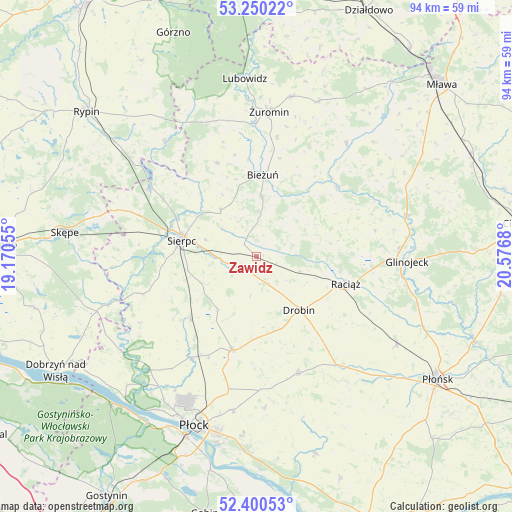
Zawidz GPS coordinates[2]
52° 49' 38.82" North, 19° 52' 25.212" East
| Map corner | latitude | longitude |
|---|---|---|
| Upper-left | 53.25022°, | 19.17055° |
| Center: | 52.82745°, | 19.87367° |
| Lower-right: | 52.40053°, | 20.5768° |
| Map W x H: | 94.5×94.5 km | = 58.7×58.7mi |
| max Lat: | 54.83135° ⇑18.9% North |
| Zawidz: | 52.82745° |
| min Lat: | ⇓81.1% South 49.21328° |
| min Long | Zawidz | max Long |
| 14.20249° | 19.87367° | 24.03723° |
| W 56.3%⇐ | ⇒43.7% E |
Elevation
Elevation of Zawidz is 120 m = 394 ft, and this is 71.4 m = 234 ft below average elevation for this country.
| Max E: |
974 m = 3196 ft | 70.4% |
| Avg. | 191.4 m = 628 ft | |
| Zawidz | 120 m = 394 ft | |
Min E: |
-3 m = -10 ft | 29.6% |
See also: Poland elevation on elevation.city.
Geographical zone
Zawidz is located in North temperate zone (between Tropic of Cancer and the Arctic Circle). Distance of this North polar circle is 1527.3 km =949 mi to North.| Distance of | km | miles | from Zawidz |
|---|---|---|---|
| North Pole | 4133.2 | 2568.3 | to North |
| Arctic Circle | 1527.3 | 949 | to North |
| Tropic Cancer | 3267.9 | 2030.6 | to South |
| Equator | 5873.9 | 3649.9 | to South |


Nearby cities:
15 places around Zawidz: (largest is in red/bold)
• Bielsk
17.9 km =11.1 mi,  194°
194°
• Bieżuń
14.9 km =9.3 mi,  4°
4°
• Drobin
12.6 km =7.8 mi,  142°
142°
• Gozdowo
17.1 km =10.6 mi,  227°
227°
• Lutocin
18.6 km =11.6 mi,  337°
337°
• Mochowo
22.4 km =13.9 mi,  252°
252°
• Raciąż
17.2 km =10.7 mi,  107°
107°
• Radzanów
19.4 km =12.1 mi,  48°
48°
• Rościszewo
10.8 km =6.7 mi,  321°
321°
• Siemiątkowo
12 km =7.5 mi,  60°
60°
• Sierpc
14.1 km =8.8 mi,  283°
283°
• Staroźreby
22.9 km =14.2 mi,  160°
160°
• Szczutowo
23.7 km =14.7 mi,  302°
302°
• Szreńsk
26.4 km =16.4 mi,  38°
38°
• Żuromin
26.6 km =16.5 mi,  5°
5°
Sources, notices
• [Note1] Compared only with cities in Poland existing in our database
• [Src1] Map data: © OpenStreetMap contributors (CC-BY-SA)
• [Src2] Other city data from geonames.org with taken over terms of usage.
• [Src3] Geographical zone / Annual Mean Temperature by Robert A. Rohde @ Wikipedia
