Raciąż geodata
Raciąż (Mazovia) is a seat of a third-order administrative division; located in Poland in Europe/Warsaw (GMT+2) time zone. With population of 4,676 people, there are 718 cities with bigger population in this country. Compared to other cities in Poland, 80.7% of cities are located further ↓South; 60.3% of cities are located further ←West and 78.4% of cities have higher elevation than Raciąż. Note1


Raciąż GPS coordinates[2]
52° 46' 53.472" North, 20° 7' 3.72" East
| Map corner | latitude | longitude |
|---|---|---|
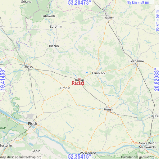
| Upper-left | 53.20473°, | 19.41458° |
| Center: | 52.78152°, | 20.1177° |
| Lower-right: | 52.35415°, | 20.82083° |
| Map W x H: | 94.6×94.6 km | = 58.8×58.8mi |
| max Lat: | 54.83135° ⇑19.3% North |
| Raciąż: | 52.78152° |
| min Lat: | ⇓80.7% South 49.21328° |
| min Long | Raciąż | max Long |
| 14.20249° | 20.1177° | 24.03723° |
| W 60.3%⇐ | ⇒39.7% E |
Elevation
Elevation of Raciąż is 103 m = 338 ft, and this is 88.4 m = 290 ft below average elevation for this country.
| Max E: |
974 m = 3196 ft | 78.4% |
| Avg. | 191.4 m = 628 ft | |
| Raciąż | 103 m = 338 ft | |
Min E: |
-3 m = -10 ft | 21.6% |
See also: Poland elevation on elevation.city.
Geographical zone
Raciąż is located in North temperate zone (between Tropic of Cancer and the Arctic Circle). Distance of this North polar circle is 1532.4 km =952.2 mi to North.| Distance of | km | miles | from Raciąż |
|---|---|---|---|
| North Pole | 4138.3 | 2571.4 | to North |
| Arctic Circle | 1532.4 | 952.2 | to North |
| Tropic Cancer | 3262.8 | 2027.4 | to South |
| Equator | 5868.8 | 3646.7 | to South |


Nearby cities:
15 places around Raciąż: (largest is in red/bold)
• Baboszewo
14.5 km =9 mi,  140°
140°
• Bielsk
24.3 km =15.1 mi,  239°
239°
• Bieżuń
25.2 km =15.7 mi,  322°
322°
• Bulkowo
26.8 km =16.7 mi,  179°
179°
• Drobin
9.9 km =6.2 mi, 240°
• Dzierzążnia
18.8 km =11.7 mi,  155°
155°
• Glinojeck
12.5 km =7.8 mi,  70°
70°
• Płońsk
24.7 km =15.3 mi, 135°
• Radzanów
18 km =11.2 mi,  354°
354°
• Siemiątkowo
12.6 km =7.8 mi,  331°
331°
• Sochocin
26.1 km =16.2 mi,  113°
113°
• Staroźreby
18.8 km =11.7 mi,  208°
208°
• Strzegowo
16.8 km =10.4 mi,  42°
42°
• Szreńsk
25.7 km =16 mi,  0°
0°
• Zawidz
17.2 km =10.7 mi,  287°
287°
Sources, notices
• [Note1] Compared only with cities in Poland existing in our database
• [Src1] Map data: © OpenStreetMap contributors (CC-BY-SA)
• [Src2] Other city data from geonames.org with taken over terms of usage.
• [Src3] Geographical zone / Annual Mean Temperature by Robert A. Rohde @ Wikipedia
