Zakopane geodata
Zakopane (Lesser Poland) is a populated place; located in Poland in Europe/Warsaw (GMT+2) time zone. With population of 27,580 people, there are 178 cities with bigger population in this country. Compared to other cities in Poland, 99.9% of cities are located further ↑North; 57.6% of cities are located further ←West and 99.9% of cities have lower elevation than Zakopane. Note1


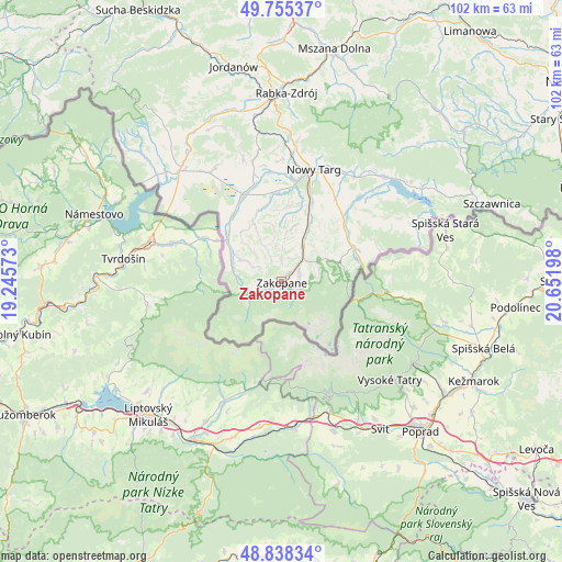
Zakopane GPS coordinates[2]
49° 17' 56.364" North, 19° 56' 55.86" East
| Map corner | latitude | longitude |
|---|---|---|
| Upper-left | 49.75537°, | 19.24573° |
| Center: | 49.29899°, | 19.94885° |
| Lower-right: | 48.83834°, | 20.65198° |
| Map W x H: | 102×102 km | = 63.4×63.4mi |
| max Lat: | 54.83135° ⇑99.9% North |
| Zakopane: | 49.29899° |
| min Lat: | ⇓0.1% South 49.21328° |
| min Long | Zakopane | max Long |
| 14.20249° | 19.94885° | 24.03723° |
| W 57.6%⇐ | ⇒42.4% E |
Elevation
Elevation of Zakopane is 819 m = 2687 ft, and this is 627.6 m = 2059 ft above average elevation for this country.
| Max E: |
974 m = 3196 ft | 0.099999999999994% |
| Zakopane | 819 m 2687 ft | |
| Avg. | 191.4 m = 628 ft | |
Min E: |
-3 m = -10 ft | 99.9% |
See also: Poland elevation on elevation.city.
Geographical zone
Zakopane is located in North temperate zone (between Tropic of Cancer and the Arctic Circle). Distance of this North polar circle is 1919.6 km =1192.8 mi to North.| Distance of | km | miles | from Zakopane |
|---|---|---|---|
| North Pole | 4525.5 | 2812 | to North |
| Arctic Circle | 1919.6 | 1192.8 | to North |
| Tropic Cancer | 2875.6 | 1786.8 | to South |
| Equator | 5481.5 | 3406 | to South |


Nearby cities:
15 places around Zakopane: (largest is in red/bold)
• Białka Tatrzańska
15.2 km =9.4 mi,  48°
48°
• Biały Dunajec
9.4 km =5.8 mi,  27°
27°
• Bukowina Tatrzańska
12.5 km =7.8 mi,  67°
67°
• Czarna Góra
15.7 km =9.8 mi,  56°
56°
• Czarny Dunajec
16.8 km =10.4 mi,  335°
335°
• Kościelisko
4.4 km =2.7 mi,  257°
257°
• Krauszów
19.5 km =12.1 mi,  1°
1°
• Leśnica
13.9 km =8.6 mi,  35°
35°
• Ludźmierz
18.8 km =11.7 mi,  7°
7°
• Nowy Targ
20.8 km =12.9 mi,  16°
16°
• Poronin
5.8 km =3.6 mi, 42°
• Szaflary
15.3 km =9.5 mi, 21°
• Trute
21.5 km =13.4 mi, 3°
• Waksmund
22.3 km =13.9 mi, 24°
• Wróblówka
17.8 km =11.1 mi,  345°
345°
Sources, notices
• [Note1] Compared only with cities in Poland existing in our database
• [Src1] Map data: © OpenStreetMap contributors (CC-BY-SA)
• [Src2] Other city data from geonames.org with taken over terms of usage.
• [Src3] Geographical zone / Annual Mean Temperature by Robert A. Rohde @ Wikipedia
