Kościelisko geodata
Kościelisko (Lesser Poland) is a seat of a third-order administrative division; located in Poland in Europe/Warsaw (GMT+2) time zone. With population of 3,900 people, there are 834 cities with bigger population in this country. Compared to other cities in Poland, 99.9% of cities are located further ↑North; 56.7% of cities are located further ←West and 100% of cities have lower elevation than Kościelisko. Note1


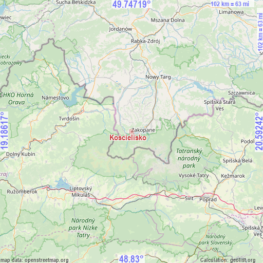
Kościelisko GPS coordinates[2]
49° 17' 26.628" North, 19° 53' 21.444" East
| Map corner | latitude | longitude |
|---|---|---|
| Upper-left | 49.74719°, | 19.18617° |
| Center: | 49.29073°, | 19.88929° |
| Lower-right: | 48.83°, | 20.59242° |
| Map W x H: | 102×102 km | = 63.4×63.4mi |
| max Lat: | 54.83135° ⇑99.9% North |
| Kościelisko: | 49.29073° |
| min Lat: | ⇓0.1% South 49.21328° |
| min Long | Kościelisko | max Long |
| 14.20249° | 19.88929° | 24.03723° |
| W 56.7%⇐ | ⇒43.3% E |
Elevation
Elevation of Kościelisko is 974 m = 3196 ft, and this is 782.6 m = 2568 ft above average elevation for this country.
| Max E: |
974 m = 3196 ft | 0% |
| Kościelisko | 974 m 3196 ft | |
| Avg. | 191.4 m = 628 ft | |
Min E: |
-3 m = -10 ft | 100% |
See also: Poland elevation on elevation.city.
Geographical zone
Kościelisko is located in North temperate zone (between Tropic of Cancer and the Arctic Circle). Distance of this North polar circle is 1920.6 km =1193.4 mi to North.| Distance of | km | miles | from Kościelisko |
|---|---|---|---|
| North Pole | 4526.4 | 2812.6 | to North |
| Arctic Circle | 1920.6 | 1193.4 | to North |
| Tropic Cancer | 2874.7 | 1786.3 | to South |
| Equator | 5480.6 | 3405.5 | to South |


Nearby cities:
15 places around Kościelisko: (largest is in red/bold)
• Białka Tatrzańska
19.1 km =11.9 mi,  54°
54°
• Biały Dunajec
12.7 km =7.9 mi,  43°
43°
• Bukowina Tatrzańska
16.9 km =10.5 mi,  69°
69°
• Chyżne
22 km =13.7 mi,  313°
313°
• Czarna Góra
19.9 km =12.4 mi,  61°
61°
• Czarny Dunajec
16.5 km =10.3 mi,  350°
350°
• Krauszów
21 km =13 mi,  13°
13°
• Leśnica
17.4 km =10.8 mi, 45°
• Ludźmierz
20.7 km =12.9 mi,  19°
19°
• Piekielnik
22.5 km =14 mi,  337°
337°
• Poronin
9.8 km =6.1 mi, 57°
• Szaflary
18.1 km =11.2 mi,  33°
33°
• Wróblówka
18.2 km =11.3 mi,  359°
359°
• Zakopane
4.4 km =2.7 mi,  77°
77°
• Załuczne
23 km =14.3 mi, 346°
Sources, notices
• [Note1] Compared only with cities in Poland existing in our database
• [Src1] Map data: © OpenStreetMap contributors (CC-BY-SA)
• [Src2] Other city data from geonames.org with taken over terms of usage.
• [Src3] Geographical zone / Annual Mean Temperature by Robert A. Rohde @ Wikipedia
