Zbrosławice geodata
Zbrosławice (Silesia) is a seat of a third-order administrative division; located in Poland in Europe/Warsaw (GMT+2) time zone. With population of 2,345 people, there are 1303 cities with bigger population in this country. Compared to other cities in Poland, 69.1% of cities are located further ↑North; 64.2% of cities are located further →East and 76.5% of cities have lower elevation than Zbrosławice. Note1


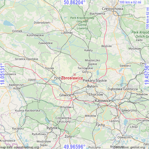
Zbrosławice GPS coordinates[2]
50° 24' 58.032" North, 18° 45' 15.948" East
| Map corner | latitude | longitude |
|---|---|---|
| Upper-left | 50.86204°, | 18.05131° |
| Center: | 50.41612°, | 18.75443° |
| Lower-right: | 49.96596°, | 19.45756° |
| Map W x H: | 99.6×99.6 km | = 61.9×61.9mi |
| max Lat: | 54.83135° ⇑69.1% North |
| Zbrosławice: | 50.41612° |
| min Lat: | ⇓30.9% South 49.21328° |
| min Long | Zbrosławice | max Long |
| 14.20249° | 18.75443° | 24.03723° |
| W 35.8%⇐ | ⇒64.2% E |
Elevation
Elevation of Zbrosławice is 252 m = 827 ft, and this is 60.6 m = 199 ft above average elevation for this country.
| Max E: |
974 m = 3196 ft | 23.5% |
| Zbrosławice | 252 m 827 ft | |
| Avg. | 191.4 m = 628 ft | |
Min E: |
-3 m = -10 ft | 76.5% |
See also: Poland elevation on elevation.city.
Geographical zone
Zbrosławice is located in North temperate zone (between Tropic of Cancer and the Arctic Circle). Distance of this North polar circle is 1795.4 km =1115.6 mi to North.| Distance of | km | miles | from Zbrosławice |
|---|---|---|---|
| North Pole | 4401.3 | 2734.8 | to North |
| Arctic Circle | 1795.4 | 1115.6 | to North |
| Tropic Cancer | 2999.8 | 1864 | to South |
| Equator | 5605.7 | 3483.2 | to South |


Nearby cities:
15 places around Zbrosławice: (largest is in red/bold)
• Bytom
14.7 km =9.1 mi,  120°
120°
• Gliwice
14.3 km =8.9 mi,  202°
202°
• Miasteczko Śląskie
16.3 km =10.1 mi,  53°
53°
• Nakło
11.3 km =7 mi,  78°
78°
• Orzech
12 km =7.5 mi, 83°
• Piekary Śląskie
12.8 km =8 mi,  108°
108°
• Pyskowice
8.8 km =5.5 mi,  258°
258°
• Radzionków
10.6 km =6.6 mi,  99°
99°
• Tarnowskie Góry
8.3 km =5.2 mi,  66°
66°
• Tworóg
13.1 km =8.1 mi,  347°
347°
• Wielowieś
14.3 km =8.9 mi,  316°
316°
• Wieszowa
3.5 km =2.2 mi,  174°
174°
• Wymysłów
16.5 km =10.3 mi,  92°
92°
• Zabrze
10.4 km =6.5 mi, 167°
• Świerklaniec
13.3 km =8.3 mi, 77°
Sources, notices
• [Note1] Compared only with cities in Poland existing in our database
• [Src1] Map data: © OpenStreetMap contributors (CC-BY-SA)
• [Src2] Other city data from geonames.org with taken over terms of usage.
• [Src3] Geographical zone / Annual Mean Temperature by Robert A. Rohde @ Wikipedia
