Wieszowa geodata
Wieszowa (Silesia) is a populated place; located in Poland in Europe/Warsaw (GMT+2) time zone. With population of 1,860 people, there are 1575 cities with bigger population in this country. Compared to other cities in Poland, 69.8% of cities are located further ↑North; 64.1% of cities are located further →East and 81.9% of cities have lower elevation than Wieszowa. Note1


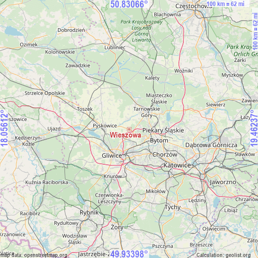
Wieszowa GPS coordinates[2]
50° 23' 3.984" North, 18° 45' 33.264" East
| Map corner | latitude | longitude |
|---|---|---|
| Upper-left | 50.83066°, | 18.05612° |
| Center: | 50.38444°, | 18.75924° |
| Lower-right: | 49.93398°, | 19.46237° |
| Map W x H: | 99.7×99.7 km | = 62×62mi |
| max Lat: | 54.83135° ⇑69.8% North |
| Wieszowa: | 50.38444° |
| min Lat: | ⇓30.2% South 49.21328° |
| min Long | Wieszowa | max Long |
| 14.20249° | 18.75924° | 24.03723° |
| W 35.9%⇐ | ⇒64.1% E |
Elevation
Elevation of Wieszowa is 275 m = 902 ft, and this is 83.6 m = 274 ft above average elevation for this country.
| Max E: |
974 m = 3196 ft | 18.1% |
| Wieszowa | 275 m 902 ft | |
| Avg. | 191.4 m = 628 ft | |
Min E: |
-3 m = -10 ft | 81.9% |
See also: Poland elevation on elevation.city.
Geographical zone
Wieszowa is located in North temperate zone (between Tropic of Cancer and the Arctic Circle). Distance of this North polar circle is 1798.9 km =1117.8 mi to North.| Distance of | km | miles | from Wieszowa |
|---|---|---|---|
| North Pole | 4404.8 | 2737 | to North |
| Arctic Circle | 1798.9 | 1117.8 | to North |
| Tropic Cancer | 2996.3 | 1861.8 | to South |
| Equator | 5602.2 | 3481 | to South |


Nearby cities:
15 places around Wieszowa: (largest is in red/bold)
• Bobrowniki
16.1 km =10 mi,  91°
91°
• Bytom
13 km =8.1 mi,  108°
108°
• Gliwice
11.3 km =7 mi,  211°
211°
• Nakło
12.2 km =7.6 mi,  61°
61°
• Orzech
12.5 km =7.8 mi,  67°
67°
• Piekary Śląskie
11.9 km =7.4 mi, 92°
• Przyszowice
15.2 km =9.4 mi,  183°
183°
• Pyskowice
9.1 km =5.7 mi,  280°
280°
• Radzionków
10.3 km =6.4 mi,  80°
80°
• Ruda Śląska
15.6 km =9.7 mi,  153°
153°
• Tarnowskie Góry
9.9 km =6.2 mi,  46°
46°
• Zabrze
6.9 km =4.3 mi,  164°
164°
• Zbrosławice
3.5 km =2.2 mi,  354°
354°
• Świerklaniec
14.2 km =8.8 mi, 62°
• Świętochłowice
14.9 km =9.3 mi,  131°
131°
Sources, notices
• [Note1] Compared only with cities in Poland existing in our database
• [Src1] Map data: © OpenStreetMap contributors (CC-BY-SA)
• [Src2] Other city data from geonames.org with taken over terms of usage.
• [Src3] Geographical zone / Annual Mean Temperature by Robert A. Rohde @ Wikipedia
