Warta geodata
Warta (Łódź Voivodeship) is a seat of a third-order administrative division; located in Poland in Europe/Warsaw (GMT+2) time zone. With population of 3,400 people, there are 934 cities with bigger population in this country. Compared to other cities in Poland, 60.3% of cities are located further ↓South; 66.1% of cities are located further →East and 66.1% of cities have higher elevation than Warta. Note1


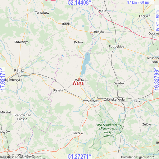
Warta GPS coordinates[2]
51° 42' 37.764" North, 18° 37' 29.388" East
| Map corner | latitude | longitude |
|---|---|---|
| Upper-left | 52.14408°, | 17.92171° |
| Center: | 51.71049°, | 18.62483° |
| Lower-right: | 51.27271°, | 19.32796° |
| Map W x H: | 96.9×96.9 km | = 60.2×60.2mi |
| max Lat: | 54.83135° ⇑39.7% North |
| Warta: | 51.71049° |
| min Lat: | ⇓60.3% South 49.21328° |
| min Long | Warta | max Long |
| 14.20249° | 18.62483° | 24.03723° |
| W 33.9%⇐ | ⇒66.1% E |
Elevation
Elevation of Warta is 130 m = 427 ft, and this is 61.4 m = 201 ft below average elevation for this country.
| Max E: |
974 m = 3196 ft | 66.1% |
| Avg. | 191.4 m = 628 ft | |
| Warta | 130 m = 427 ft | |
Min E: |
-3 m = -10 ft | 33.9% |
See also: Poland elevation on elevation.city.
Geographical zone
Warta is located in North temperate zone (between Tropic of Cancer and the Arctic Circle). Distance of this North polar circle is 1651.5 km =1026.2 mi to North.| Distance of | km | miles | from Warta |
|---|---|---|---|
| North Pole | 4257.4 | 2645.4 | to North |
| Arctic Circle | 1651.5 | 1026.2 | to North |
| Tropic Cancer | 3143.7 | 1953.4 | to South |
| Equator | 5749.7 | 3572.7 | to South |


Nearby cities:
15 places around Warta: (largest is in red/bold)
• Borysławice
15.1 km =9.4 mi,  244°
244°
• Brzeźnio
24.1 km =15 mi,  180°
180°
• Błaszki
14.6 km =9.1 mi, 243°
• Dobra
22.9 km =14.2 mi,  358°
358°
• Goszczanów
12.2 km =7.6 mi,  317°
317°
• Kawęczyn
23 km =14.3 mi,  343°
343°
• Koźminek
22 km =13.7 mi,  296°
296°
• Lisków
20.7 km =12.9 mi,  311°
311°
• Pęczniew
12.4 km =7.7 mi,  33°
33°
• Sieradz
14.7 km =9.1 mi,  150°
150°
• Szadek
24.3 km =15.1 mi,  94°
94°
• Szczytniki
20.4 km =12.7 mi,  263°
263°
• Wojsławice
21.6 km =13.4 mi,  107°
107°
• Wróblew
11 km =6.8 mi, 183°
• Zadzim
17.1 km =10.6 mi,  64°
64°
Sources, notices
• [Note1] Compared only with cities in Poland existing in our database
• [Src1] Map data: © OpenStreetMap contributors (CC-BY-SA)
• [Src2] Other city data from geonames.org with taken over terms of usage.
• [Src3] Geographical zone / Annual Mean Temperature by Robert A. Rohde @ Wikipedia
