Pęczniew geodata
Pęczniew (Łódź Voivodeship) is a seat of a third-order administrative division; located in Poland in Europe/Warsaw (GMT+2) time zone. With population of 3,871 people, there are 841 cities with bigger population in this country. Compared to other cities in Poland, 62.2% of cities are located further ↓South; 64.7% of cities are located further →East and 71.1% of cities have higher elevation than Pęczniew. Note1


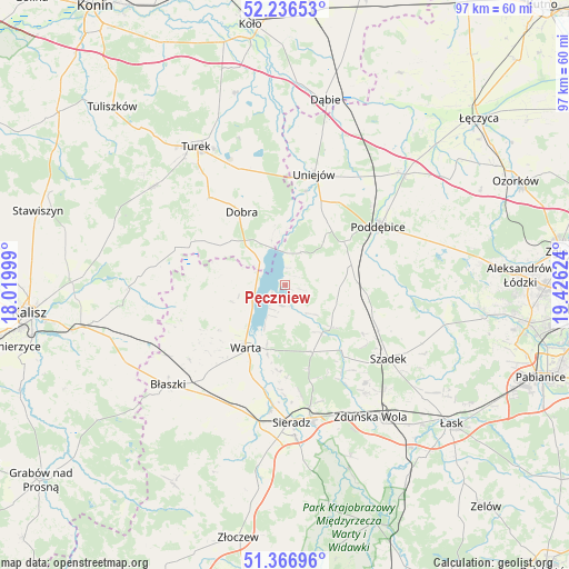
Pęczniew GPS coordinates[2]
51° 48' 13.824" North, 18° 43' 23.196" East
| Map corner | latitude | longitude |
|---|---|---|
| Upper-left | 52.23653°, | 18.01999° |
| Center: | 51.80384°, | 18.72311° |
| Lower-right: | 51.36696°, | 19.42624° |
| Map W x H: | 96.7×96.7 km | = 60.1×60.1mi |
| max Lat: | 54.83135° ⇑37.8% North |
| Pęczniew: | 51.80384° |
| min Lat: | ⇓62.2% South 49.21328° |
| min Long | Pęczniew | max Long |
| 14.20249° | 18.72311° | 24.03723° |
| W 35.3%⇐ | ⇒64.7% E |
Elevation
Elevation of Pęczniew is 119 m = 390 ft, and this is 72.4 m = 238 ft below average elevation for this country.
| Max E: |
974 m = 3196 ft | 71.1% |
| Avg. | 191.4 m = 628 ft | |
| Pęczniew | 119 m = 390 ft | |
Min E: |
-3 m = -10 ft | 28.9% |
See also: Poland elevation on elevation.city.
Geographical zone
Pęczniew is located in North temperate zone (between Tropic of Cancer and the Arctic Circle). Distance of this North polar circle is 1641.1 km =1019.7 mi to North.| Distance of | km | miles | from Pęczniew |
|---|---|---|---|
| North Pole | 4247 | 2639 | to North |
| Arctic Circle | 1641.1 | 1019.7 | to North |
| Tropic Cancer | 3154.1 | 1959.9 | to South |
| Equator | 5760 | 3579.1 | to South |


Nearby cities:
15 places around Pęczniew: (largest is in red/bold)
• Borysławice
26.4 km =16.4 mi,  230°
230°
• Błaszki
26.1 km =16.2 mi, 229°
• Dobra
14.6 km =9.1 mi,  329°
329°
• Goszczanów
15 km =9.3 mi,  264°
264°
• Kawęczyn
17.6 km =10.9 mi,  311°
311°
• Lisków
22.6 km =14 mi,  278°
278°
• Poddębice
18.9 km =11.7 mi,  58°
58°
• Przykona
21.2 km =13.2 mi,  338°
338°
• Sieradz
23.1 km =14.4 mi,  178°
178°
• Szadek
21.4 km =13.3 mi,  125°
125°
• Uniejów
19.5 km =12.1 mi,  14°
14°
• Warta
12.4 km =7.7 mi,  213°
213°
• Wojsławice
21.8 km =13.5 mi,  140°
140°
• Wróblew
22.6 km =14 mi,  199°
199°
• Zadzim
9.2 km =5.7 mi,  109°
109°
Sources, notices
• [Note1] Compared only with cities in Poland existing in our database
• [Src1] Map data: © OpenStreetMap contributors (CC-BY-SA)
• [Src2] Other city data from geonames.org with taken over terms of usage.
• [Src3] Geographical zone / Annual Mean Temperature by Robert A. Rohde @ Wikipedia
