Brzeziny geodata
Brzeziny (Łódź Voivodeship) is a seat of a second-order administrative division; located in Poland in Europe/Warsaw (GMT+2) time zone. With population of 12,289 people, there are 386 cities with bigger population in this country. Compared to other cities in Poland, 62.2% of cities are located further ↓South; 53.8% of cities are located further ←West and 57.5% of cities have lower elevation than Brzeziny. Note1


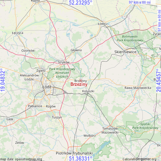
Brzeziny GPS coordinates[2]
51° 48' 0.828" North, 19° 45' 5.184" East
| Map corner | latitude | longitude |
|---|---|---|
| Upper-left | 52.23295°, | 19.04832° |
| Center: | 51.80023°, | 19.75144° |
| Lower-right: | 51.36331°, | 20.45457° |
| Map W x H: | 96.7×96.7 km | = 60.1×60.1mi |
| max Lat: | 54.83135° ⇑37.8% North |
| Brzeziny: | 51.80023° |
| min Lat: | ⇓62.2% South 49.21328° |
| min Long | Brzeziny | max Long |
| 14.20249° | 19.75144° | 24.03723° |
| W 53.8%⇐ | ⇒46.2% E |
Elevation
Elevation of Brzeziny is 192 m = 630 ft, and this is 0.59999999999999 m = 2 ft above average elevation for this country.
| Max E: |
974 m = 3196 ft | 42.5% |
| Brzeziny | 192 m 630 ft | |
| Avg. | 191.4 m = 628 ft | |
Min E: |
-3 m = -10 ft | 57.5% |
See also: Poland elevation on elevation.city.
Geographical zone
Brzeziny is located in North temperate zone (between Tropic of Cancer and the Arctic Circle). Distance of this North polar circle is 1641.5 km =1020 mi to North.| Distance of | km | miles | from Brzeziny |
|---|---|---|---|
| North Pole | 4247.4 | 2639.2 | to North |
| Arctic Circle | 1641.5 | 1020 | to North |
| Tropic Cancer | 3153.7 | 1959.6 | to South |
| Equator | 5759.6 | 3578.8 | to South |


Nearby cities:
15 places around Brzeziny: (largest is in red/bold)
• Andrespol
11 km =6.8 mi,  223°
223°
• Brójce
16.7 km =10.4 mi,  205°
205°
• Dmosin
13.8 km =8.6 mi,  2°
2°
• Dobra
15.2 km =9.4 mi,  300°
300°
• Gałków Duży
7.4 km =4.6 mi,  194°
194°
• Gałków Mały
8.7 km =5.4 mi,  197°
197°
• Jeżów
15 km =9.3 mi,  84°
84°
• Koluszki
8.3 km =5.2 mi,  145°
145°
• Lipce Reymontowskie
17 km =10.6 mi,  50°
50°
• Rogów
9.5 km =5.9 mi, 78°
• Rokiciny
17 km =10.6 mi,  168°
168°
• Rokiciny-Kolonia
15.2 km =9.4 mi, 171°
• Stryków
15.1 km =9.4 mi,  318°
318°
• Słupia
16.2 km =10.1 mi,  67°
67°
• Wola Rakowa
17.1 km =10.6 mi, 214°
Sources, notices
• [Note1] Compared only with cities in Poland existing in our database
• [Src1] Map data: © OpenStreetMap contributors (CC-BY-SA)
• [Src2] Other city data from geonames.org with taken over terms of usage.
• [Src3] Geographical zone / Annual Mean Temperature by Robert A. Rohde @ Wikipedia
