Wilkowo geodata
Wilkowo (Lubusz) is a populated place; located in Poland in Europe/Warsaw (GMT+2) time zone. With population of 1,000 people, there are 2459 cities with bigger population in this country. Compared to other cities in Poland, 71.6% of cities are located further ↓South; 95.5% of cities are located further →East and 86.1% of cities have higher elevation than Wilkowo. Note1


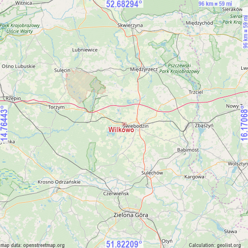
Wilkowo GPS coordinates[2]
52° 15' 16.56" North, 15° 28' 3.18" East
| Map corner | latitude | longitude |
|---|---|---|
| Upper-left | 52.68294°, | 14.76443° |
| Center: | 52.2546°, | 15.46755° |
| Lower-right: | 51.82209°, | 16.17068° |
| Map W x H: | 95.7×95.7 km | = 59.5×59.5mi |
| max Lat: | 54.83135° ⇑28.4% North |
| Wilkowo: | 52.2546° |
| min Lat: | ⇓71.6% South 49.21328° |
| min Long | Wilkowo | max Long |
| 14.20249° | 15.46755° | 24.03723° |
| W 4.5%⇐ | ⇒95.5% E |
Elevation
Elevation of Wilkowo is 87 m = 285 ft, and this is 104.4 m = 343 ft below average elevation for this country.
| Max E: |
974 m = 3196 ft | 86.1% |
| Avg. | 191.4 m = 628 ft | |
| Wilkowo | 87 m = 285 ft | |
Min E: |
-3 m = -10 ft | 13.9% |
See also: Poland elevation on elevation.city.
Geographical zone
Wilkowo is located in North temperate zone (between Tropic of Cancer and the Arctic Circle). Distance of this North polar circle is 1591 km =988.6 mi to North.| Distance of | km | miles | from Wilkowo |
|---|---|---|---|
| North Pole | 4196.9 | 2607.8 | to North |
| Arctic Circle | 1591 | 988.6 | to North |
| Tropic Cancer | 3204.2 | 1991 | to South |
| Equator | 5810.2 | 3610.3 | to South |


Nearby cities:
15 places around Wilkowo: (largest is in red/bold)
• Brody
21.6 km =13.4 mi,  186°
186°
• Brójce
15.7 km =9.8 mi,  63°
63°
• Bytnica
23.4 km =14.5 mi,  240°
240°
• Cigacice
26.2 km =16.3 mi,  157°
157°
• Kije
18.1 km =11.2 mi, 163°
• Lubrza
5.8 km =3.6 mi,  343°
343°
• Międzylesie
13.5 km =8.4 mi,  205°
205°
• Międzyrzecz
22.4 km =13.9 mi,  19°
19°
• Sieniawa
13.6 km =8.5 mi,  333°
333°
• Skąpe
11.3 km =7 mi,  183°
183°
• Sulechów
21.8 km =13.5 mi,  150°
150°
• Szczaniec
14.7 km =9.1 mi,  83°
83°
• Zbąszynek
23.8 km =14.8 mi,  93°
93°
• Łagów
14.6 km =9.1 mi,  307°
307°
• Świebodzin
4.6 km =2.9 mi,  99°
99°
Sources, notices
• [Note1] Compared only with cities in Poland existing in our database
• [Src1] Map data: © OpenStreetMap contributors (CC-BY-SA)
• [Src2] Other city data from geonames.org with taken over terms of usage.
• [Src3] Geographical zone / Annual Mean Temperature by Robert A. Rohde @ Wikipedia
