Lubrza geodata
Lubrza (Lubusz) is a seat of a third-order administrative division; located in Poland in Europe/Warsaw (GMT+2) time zone. With population of 995 people, there are 2505 cities with bigger population in this country. Compared to other cities in Poland, 72.6% of cities are located further ↓South; 95.6% of cities are located further →East and 90.2% of cities have higher elevation than Lubrza. Note1


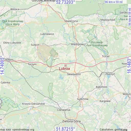
Lubrza GPS coordinates[2]
52° 18' 15.048" North, 15° 26' 35.412" East
| Map corner | latitude | longitude |
|---|---|---|
| Upper-left | 52.73203°, | 14.74005° |
| Center: | 52.30418°, | 15.44317° |
| Lower-right: | 51.87215°, | 16.1463° |
| Map W x H: | 95.6×95.6 km | = 59.4×59.4mi |
| max Lat: | 54.83135° ⇑27.4% North |
| Lubrza: | 52.30418° |
| min Lat: | ⇓72.6% South 49.21328° |
| min Long | Lubrza | max Long |
| 14.20249° | 15.44317° | 24.03723° |
| W 4.4%⇐ | ⇒95.6% E |
Elevation
Elevation of Lubrza is 75 m = 246 ft, and this is 116.4 m = 382 ft below average elevation for this country.
| Max E: |
974 m = 3196 ft | 90.2% |
| Avg. | 191.4 m = 628 ft | |
| Lubrza | 75 m = 246 ft | |
Min E: |
-3 m = -10 ft | 9.8% |
See also: Poland elevation on elevation.city.
Geographical zone
Lubrza is located in North temperate zone (between Tropic of Cancer and the Arctic Circle). Distance of this North polar circle is 1585.5 km =985.2 mi to North.| Distance of | km | miles | from Lubrza |
|---|---|---|---|
| North Pole | 4191.4 | 2604.4 | to North |
| Arctic Circle | 1585.5 | 985.2 | to North |
| Tropic Cancer | 3209.8 | 1994.5 | to South |
| Equator | 5815.7 | 3613.7 | to South |


Nearby cities:
15 places around Lubrza: (largest is in red/bold)
• Bledzew
23.8 km =14.8 mi,  355°
355°
• Brójce
15.8 km =9.8 mi,  84°
84°
• Bytnica
25.3 km =15.7 mi,  227°
227°
• Glisno
23.5 km =14.6 mi,  324°
324°
• Kije
23.8 km =14.8 mi,  163°
163°
• Międzylesie
18.2 km =11.3 mi,  193°
193°
• Międzyrzecz
18.1 km =11.2 mi,  30°
30°
• Sieniawa
8 km =5 mi,  325°
325°
• Skąpe
16.9 km =10.5 mi,  176°
176°
• Szczaniec
16.7 km =10.4 mi,  103°
103°
• Torzym
24.5 km =15.2 mi,  272°
272°
• Wilkowo
5.8 km =3.6 mi, 163°
• Zbąszynek
26.3 km =16.3 mi, 104°
• Łagów
10.4 km =6.5 mi,  288°
288°
• Świebodzin
8.8 km =5.5 mi,  135°
135°
Sources, notices
• [Note1] Compared only with cities in Poland existing in our database
• [Src1] Map data: © OpenStreetMap contributors (CC-BY-SA)
• [Src2] Other city data from geonames.org with taken over terms of usage.
• [Src3] Geographical zone / Annual Mean Temperature by Robert A. Rohde @ Wikipedia
