Bytnica geodata
Bytnica (Lubusz) is a seat of a third-order administrative division; located in Poland in Europe/Warsaw (GMT+2) time zone. With population of 1,200 people, there are 2164 cities with bigger population in this country. Compared to other cities in Poland, 68.9% of cities are located further ↓South; 97% of cities are located further →East and 91.1% of cities have higher elevation than Bytnica. Note1


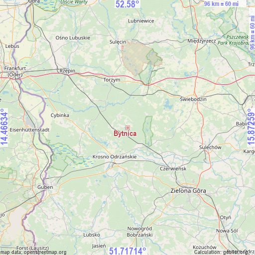
Bytnica GPS coordinates[2]
52° 9' 2.376" North, 15° 10' 10.056" East
| Map corner | latitude | longitude |
|---|---|---|
| Upper-left | 52.58°, | 14.46634° |
| Center: | 52.15066°, | 15.16946° |
| Lower-right: | 51.71714°, | 15.87259° |
| Map W x H: | 95.9×95.9 km | = 59.6×59.6mi |
| max Lat: | 54.83135° ⇑31.1% North |
| Bytnica: | 52.15066° |
| min Lat: | ⇓68.9% South 49.21328° |
| min Long | Bytnica | max Long |
| 14.20249° | 15.16946° | 24.03723° |
| W 3%⇐ | ⇒97% E |
Elevation
Elevation of Bytnica is 70 m = 230 ft, and this is 121.4 m = 398 ft below average elevation for this country.
| Max E: |
974 m = 3196 ft | 91.1% |
| Avg. | 191.4 m = 628 ft | |
| Bytnica | 70 m = 230 ft | |
Min E: |
-3 m = -10 ft | 8.9% |
See also: Poland elevation on elevation.city.
Geographical zone
Bytnica is located in North temperate zone (between Tropic of Cancer and the Arctic Circle). Distance of this North polar circle is 1602.6 km =995.8 mi to North.| Distance of | km | miles | from Bytnica |
|---|---|---|---|
| North Pole | 4208.5 | 2615 | to North |
| Arctic Circle | 1602.6 | 995.8 | to North |
| Tropic Cancer | 3192.7 | 1983.9 | to South |
| Equator | 5798.6 | 3603.1 | to South |


Nearby cities:
15 places around Bytnica: (largest is in red/bold)
• Bobrowice
23.1 km =14.4 mi,  193°
193°
• Boczów
24.4 km =15.2 mi,  321°
321°
• Brody
20.6 km =12.8 mi,  118°
118°
• Czerwieńsk
23.1 km =14.4 mi,  131°
131°
• Dychów
19.7 km =12.2 mi,  202°
202°
• Dąbie
15.6 km =9.7 mi,  184°
184°
• Krosno Odrzańskie
11.7 km =7.3 mi, 204°
• Maszewo
20.2 km =12.6 mi,  243°
243°
• Międzylesie
14.6 km =9.1 mi,  92°
92°
• Osiecznica
11.6 km =7.2 mi,  224°
224°
• Ploty
24.8 km =15.4 mi,  137°
137°
• Skąpe
19.7 km =12.2 mi, 89°
• Torzym
19 km =11.8 mi,  341°
341°
• Wilkowo
23.4 km =14.5 mi,  60°
60°
• Łagów
22.2 km =13.8 mi,  23°
23°
Sources, notices
• [Note1] Compared only with cities in Poland existing in our database
• [Src1] Map data: © OpenStreetMap contributors (CC-BY-SA)
• [Src2] Other city data from geonames.org with taken over terms of usage.
• [Src3] Geographical zone / Annual Mean Temperature by Robert A. Rohde @ Wikipedia
