Sieniawa geodata
Sieniawa (Lubusz) is a populated place; located in Poland in Europe/Warsaw (GMT+2) time zone. With population of 1,100 people, there are 2307 cities with bigger population in this country. Compared to other cities in Poland, 73.9% of cities are located further ↓South; 96.2% of cities are located further →East and 64.7% of cities have higher elevation than Sieniawa. Note1


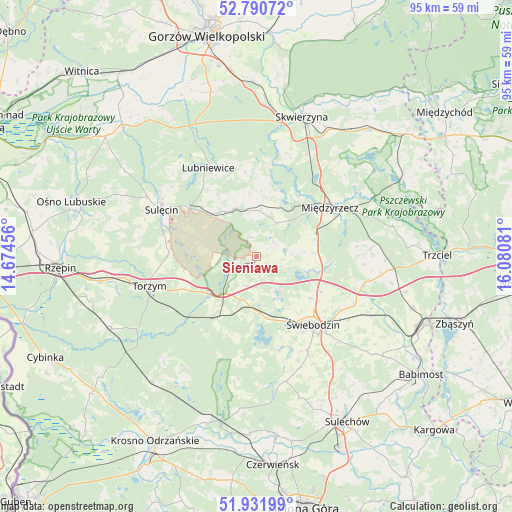
Sieniawa GPS coordinates[2]
52° 21' 48.384" North, 15° 22' 39.648" East
| Map corner | latitude | longitude |
|---|---|---|
| Upper-left | 52.79072°, | 14.67456° |
| Center: | 52.36344°, | 15.37768° |
| Lower-right: | 51.93199°, | 16.08081° |
| Map W x H: | 95.5×95.5 km | = 59.3×59.3mi |
| max Lat: | 54.83135° ⇑26.1% North |
| Sieniawa: | 52.36344° |
| min Lat: | ⇓73.9% South 49.21328° |
| min Long | Sieniawa | max Long |
| 14.20249° | 15.37768° | 24.03723° |
| W 3.8%⇐ | ⇒96.2% E |
Elevation
Elevation of Sieniawa is 134 m = 440 ft, and this is 57.4 m = 188 ft below average elevation for this country.
| Max E: |
974 m = 3196 ft | 64.7% |
| Avg. | 191.4 m = 628 ft | |
| Sieniawa | 134 m = 440 ft | |
Min E: |
-3 m = -10 ft | 35.3% |
See also: Poland elevation on elevation.city.
Geographical zone
Sieniawa is located in North temperate zone (between Tropic of Cancer and the Arctic Circle). Distance of this North polar circle is 1578.9 km =981.1 mi to North.| Distance of | km | miles | from Sieniawa |
|---|---|---|---|
| North Pole | 4184.8 | 2600.3 | to North |
| Arctic Circle | 1578.9 | 981.1 | to North |
| Tropic Cancer | 3216.3 | 1998.5 | to South |
| Equator | 5822.3 | 3617.8 | to South |


Nearby cities:
15 places around Sieniawa: (largest is in red/bold)
• Bledzew
17.3 km =10.7 mi,  8°
8°
• Brójce
20.8 km =12.9 mi,  104°
104°
• Glisno
15.5 km =9.6 mi,  323°
323°
• Lubniewice
19.1 km =11.9 mi,  333°
333°
• Lubrza
8 km =5 mi,  145°
145°
• Międzylesie
24.3 km =15.1 mi,  179°
179°
• Międzyrzecz
16.3 km =10.1 mi,  56°
56°
• Skwierzyna
27.6 km =17.1 mi,  18°
18°
• Skąpe
24 km =14.9 mi,  166°
166°
• Sulęcin
19.9 km =12.4 mi,  296°
296°
• Szczaniec
23.2 km =14.4 mi,  117°
117°
• Torzym
20.8 km =12.9 mi,  254°
254°
• Wilkowo
13.6 km =8.5 mi, 153°
• Łagów
6.3 km =3.9 mi,  239°
239°
• Świebodzin
16.7 km =10.4 mi,  140°
140°
Sources, notices
• [Note1] Compared only with cities in Poland existing in our database
• [Src1] Map data: © OpenStreetMap contributors (CC-BY-SA)
• [Src2] Other city data from geonames.org with taken over terms of usage.
• [Src3] Geographical zone / Annual Mean Temperature by Robert A. Rohde @ Wikipedia
