Wilkowice geodata
Wilkowice (Greater Poland) is a populated place; located in Poland in Europe/Warsaw (GMT+2) time zone. With population of 1,589 people, there are 1781 cities with bigger population in this country. Compared to other cities in Poland, 63.4% of cities are located further ↓South; 89.3% of cities are located further →East and 75% of cities have higher elevation than Wilkowice. Note1


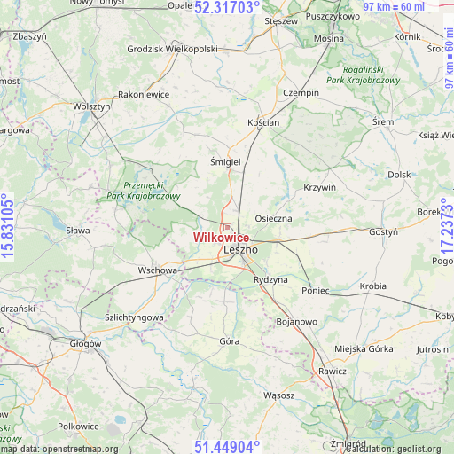
Wilkowice GPS coordinates[2]
51° 53' 6.468" North, 16° 32' 3.012" East
| Map corner | latitude | longitude |
|---|---|---|
| Upper-left | 52.31703°, | 15.83105° |
| Center: | 51.88513°, | 16.53417° |
| Lower-right: | 51.44904°, | 17.2373° |
| Map W x H: | 96.5×96.5 km | = 60×60mi |
| max Lat: | 54.83135° ⇑36.6% North |
| Wilkowice: | 51.88513° |
| min Lat: | ⇓63.4% South 49.21328° |
| min Long | Wilkowice | max Long |
| 14.20249° | 16.53417° | 24.03723° |
| W 10.7%⇐ | ⇒89.3% E |
Elevation
Elevation of Wilkowice is 111 m = 364 ft, and this is 80.4 m = 264 ft below average elevation for this country.
| Max E: |
974 m = 3196 ft | 75% |
| Avg. | 191.4 m = 628 ft | |
| Wilkowice | 111 m = 364 ft | |
Min E: |
-3 m = -10 ft | 25% |
See also: Poland elevation on elevation.city.
Geographical zone
Wilkowice is located in North temperate zone (between Tropic of Cancer and the Arctic Circle). Distance of this North polar circle is 1632.1 km =1014.1 mi to North.| Distance of | km | miles | from Wilkowice |
|---|---|---|---|
| North Pole | 4238 | 2633.4 | to North |
| Arctic Circle | 1632.1 | 1014.1 | to North |
| Tropic Cancer | 3163.2 | 1965.5 | to South |
| Equator | 5769.1 | 3584.8 | to South |


Nearby cities:
15 places around Wilkowice: (largest is in red/bold)
• Bojanowo Stare
12.5 km =7.8 mi,  15°
15°
• Brenno
22.3 km =13.9 mi,  280°
280°
• Chróścina
15.7 km =9.8 mi,  178°
178°
• Krzemieniewo
20.8 km =12.9 mi,  98°
98°
• Krzywiń
21.4 km =13.3 mi,  66°
66°
• Leszno
5.7 km =3.5 mi,  150°
150°
• Lipno
4.2 km =2.6 mi,  32°
32°
• Osieczna
10.1 km =6.3 mi,  77°
77°
• Poniec
23.2 km =14.4 mi,  125°
125°
• Przemęt
21 km =13 mi,  310°
310°
• Rydzyna
14.3 km =8.9 mi,  140°
140°
• Wschowa
17.3 km =10.7 mi,  239°
239°
• Włoszakowice
12.6 km =7.8 mi,  292°
292°
• Śmigiel
14.3 km =8.9 mi,  358°
358°
• Święciechowa
4.2 km =2.6 mi,  216°
216°
Sources, notices
• [Note1] Compared only with cities in Poland existing in our database
• [Src1] Map data: © OpenStreetMap contributors (CC-BY-SA)
• [Src2] Other city data from geonames.org with taken over terms of usage.
• [Src3] Geographical zone / Annual Mean Temperature by Robert A. Rohde @ Wikipedia
