Rydzyna geodata
Rydzyna (Greater Poland) is a seat of a third-order administrative division; located in Poland in Europe/Warsaw (GMT+2) time zone. With population of 2,696 people, there are 1172 cities with bigger population in this country. Compared to other cities in Poland, 61.8% of cities are located further ↓South; 88.3% of cities are located further →East and 85.7% of cities have higher elevation than Rydzyna. Note1


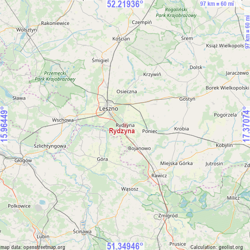
Rydzyna GPS coordinates[2]
51° 47' 11.436" North, 16° 40' 3.396" East
| Map corner | latitude | longitude |
|---|---|---|
| Upper-left | 52.21936°, | 15.96449° |
| Center: | 51.78651°, | 16.66761° |
| Lower-right: | 51.34946°, | 17.37074° |
| Map W x H: | 96.7×96.7 km | = 60.1×60.1mi |
| max Lat: | 54.83135° ⇑38.2% North |
| Rydzyna: | 51.78651° |
| min Lat: | ⇓61.8% South 49.21328° |
| min Long | Rydzyna | max Long |
| 14.20249° | 16.66761° | 24.03723° |
| W 11.7%⇐ | ⇒88.3% E |
Elevation
Elevation of Rydzyna is 88 m = 289 ft, and this is 103.4 m = 339 ft below average elevation for this country.
| Max E: |
974 m = 3196 ft | 85.7% |
| Avg. | 191.4 m = 628 ft | |
| Rydzyna | 88 m = 289 ft | |
Min E: |
-3 m = -10 ft | 14.3% |
See also: Poland elevation on elevation.city.
Geographical zone
Rydzyna is located in North temperate zone (between Tropic of Cancer and the Arctic Circle). Distance of this North polar circle is 1643.1 km =1021 mi to North.| Distance of | km | miles | from Rydzyna |
|---|---|---|---|
| North Pole | 4248.9 | 2640.1 | to North |
| Arctic Circle | 1643.1 | 1021 | to North |
| Tropic Cancer | 3152.2 | 1958.7 | to South |
| Equator | 5758.1 | 3577.9 | to South |


Nearby cities:
15 places around Rydzyna: (largest is in red/bold)
• Bojanowo
10.4 km =6.5 mi,  147°
147°
• Chróścina
10 km =6.2 mi,  241°
241°
• Golina Wielka
12.5 km =7.8 mi,  140°
140°
• Góra
16.2 km =10.1 mi,  214°
214°
• Krobia
21.7 km =13.5 mi,  93°
93°
• Krzemieniewo
14 km =8.7 mi,  54°
54°
• Krzywiń
22.2 km =13.8 mi,  28°
28°
• Leszno
8.7 km =5.4 mi,  313°
313°
• Lipno
16.1 km =10 mi,  334°
334°
• Niechlów
23.3 km =14.5 mi, 242°
• Osieczna
13.1 km =8.1 mi,  3°
3°
• Poniec
10 km =6.2 mi,  104°
104°
• Rawicz
23.7 km =14.7 mi, 146°
• Wilkowice
14.3 km =8.9 mi,  320°
320°
• Święciechowa
13.9 km =8.6 mi,  303°
303°
Sources, notices
• [Note1] Compared only with cities in Poland existing in our database
• [Src1] Map data: © OpenStreetMap contributors (CC-BY-SA)
• [Src2] Other city data from geonames.org with taken over terms of usage.
• [Src3] Geographical zone / Annual Mean Temperature by Robert A. Rohde @ Wikipedia
