Włoszakowice geodata
Włoszakowice (Greater Poland) is a seat of a third-order administrative division; located in Poland in Europe/Warsaw (GMT+2) time zone. With population of 3,159 people, there are 1002 cities with bigger population in this country. Compared to other cities in Poland, 64.3% of cities are located further ↓South; 90.4% of cities are located further →East and 85.7% of cities have higher elevation than Włoszakowice. Note1
Administrative division(s):
- Level 1: Greater Poland
- Level 2: Powiat leszczyński
- Level 3: Włoszakowice


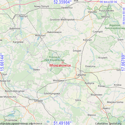
Włoszakowice GPS coordinates[2]
51° 55' 39.144" North, 16° 21' 52.416" East
| Map corner | latitude | longitude |
|---|---|---|
| Upper-left | 52.35904°, | 15.66144° |
| Center: | 51.92754°, | 16.36456° |
| Lower-right: | 51.49186°, | 17.06769° |
| Map W x H: | 96.4×96.4 km | = 59.9×59.9mi |
| max Lat: | 54.83135° ⇑35.7% North |
| Włoszakowice: | 51.92754° |
| min Lat: | ⇓64.3% South 49.21328° |
| min Long | Włoszakowice | max Long |
| 14.20249° | 16.36456° | 24.03723° |
| W 9.6%⇐ | ⇒90.4% E |
Elevation
Elevation of Włoszakowice is 88 m = 289 ft, and this is 103.4 m = 339 ft below average elevation for this country.
| Max E: |
974 m = 3196 ft | 85.7% |
| Avg. | 191.4 m = 628 ft | |
| Włoszakowice | 88 m = 289 ft | |
Min E: |
-3 m = -10 ft | 14.3% |
See also: Poland elevation on elevation.city.
Geographical zone
Włoszakowice is located in North temperate zone (between Tropic of Cancer and the Arctic Circle). Distance of this North polar circle is 1627.4 km =1011.2 mi to North.| Distance of | km | miles | from Włoszakowice |
|---|---|---|---|
| North Pole | 4233.3 | 2630.4 | to North |
| Arctic Circle | 1627.4 | 1011.2 | to North |
| Tropic Cancer | 3167.9 | 1968.4 | to South |
| Equator | 5773.8 | 3587.7 | to South |


Nearby cities:
15 places around Włoszakowice: (largest is in red/bold)
• Bojanowo Stare
16.7 km =10.4 mi,  64°
64°
• Brenno
10.3 km =6.4 mi,  266°
266°
• Chróścina
23.7 km =14.7 mi,  149°
149°
• Leszno
17.4 km =10.8 mi,  123°
123°
• Lipno
13.9 km =8.6 mi,  94°
94°
• Osieczna
21.7 km =13.5 mi,  96°
96°
• Przemęt
10 km =6.2 mi,  334°
334°
• Rakoniewice
24.3 km =15.1 mi,  345°
345°
• Sława
20.9 km =13 mi,  254°
254°
• Wielichowo
20.9 km =13 mi,  357°
357°
• Wijewo
12.3 km =7.6 mi,  264°
264°
• Wilkowice
12.6 km =7.8 mi,  112°
112°
• Wschowa
13.8 km =8.6 mi,  193°
193°
• Śmigiel
14.7 km =9.1 mi,  49°
49°
• Święciechowa
12.2 km =7.6 mi,  131°
131°
Sources, notices
• [Note1] Compared only with cities in Poland existing in our database
• [Src1] Map data: © OpenStreetMap contributors (CC-BY-SA)
• [Src2] Other city data from geonames.org with taken over terms of usage.
• [Src3] Geographical zone / Annual Mean Temperature by Robert A. Rohde @ Wikipedia
