Paszowice geodata
Paszowice (Lower Silesia) is a populated place; located in Poland in Europe/Warsaw (GMT+2) time zone. With population of 1,429 people, there are 1927 cities with bigger population in this country. Compared to other cities in Poland, 55.3% of cities are located further ↑North; 91.7% of cities are located further →East and 69.8% of cities have lower elevation than Paszowice. Note1


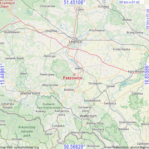
Paszowice GPS coordinates[2]
51° 0' 38.808" North, 16° 9' 9.828" East
| Map corner | latitude | longitude |
|---|---|---|
| Upper-left | 51.45106°, | 15.44961° |
| Center: | 51.01078°, | 16.15273° |
| Lower-right: | 50.56628°, | 16.85586° |
| Map W x H: | 98.4×98.4 km | = 61.1×61.1mi |
| max Lat: | 54.83135° ⇑55.3% North |
| Paszowice: | 51.01078° |
| min Lat: | ⇓44.7% South 49.21328° |
| min Long | Paszowice | max Long |
| 14.20249° | 16.15273° | 24.03723° |
| W 8.3%⇐ | ⇒91.7% E |
Elevation
Elevation of Paszowice is 229 m = 751 ft, and this is 37.6 m = 123 ft above average elevation for this country.
| Max E: |
974 m = 3196 ft | 30.2% |
| Paszowice | 229 m 751 ft | |
| Avg. | 191.4 m = 628 ft | |
Min E: |
-3 m = -10 ft | 69.8% |
See also: Poland elevation on elevation.city.
Geographical zone
Paszowice is located in North temperate zone (between Tropic of Cancer and the Arctic Circle). Distance of this North polar circle is 1729.3 km =1074.5 mi to North.| Distance of | km | miles | from Paszowice |
|---|---|---|---|
| North Pole | 4335.2 | 2693.8 | to North |
| Arctic Circle | 1729.3 | 1074.5 | to North |
| Tropic Cancer | 3065.9 | 1905.1 | to South |
| Equator | 5671.9 | 3524.4 | to South |


Nearby cities:
15 places around Paszowice: (largest is in red/bold)
• Bolków
10.5 km =6.5 mi,  200°
200°
• Dobromierz
12.7 km =7.9 mi,  150°
150°
• Jawor
5.3 km =3.3 mi,  32°
32°
• Konary
17 km =10.6 mi,  78°
78°
• Krotoszyce
16.9 km =10.5 mi,  333°
333°
• Legnickie Pole
16.1 km =10 mi,  22°
22°
• Mierczyce
14.5 km =9 mi,  50°
50°
• Męcinka
8 km =5 mi, 330°
• Stanowice
17.9 km =11.1 mi,  119°
119°
• Strzegom
14.8 km =9.2 mi,  111°
111°
• Wierzchosławice
14 km =8.7 mi, 197°
• Wilków
18.1 km =11.2 mi,  299°
299°
• Wojcieszów
17.4 km =10.8 mi,  247°
247°
• Wądroże Wielkie
17.2 km =10.7 mi, 46°
• Świerzawa
18 km =11.2 mi,  271°
271°
Sources, notices
• [Note1] Compared only with cities in Poland existing in our database
• [Src1] Map data: © OpenStreetMap contributors (CC-BY-SA)
• [Src2] Other city data from geonames.org with taken over terms of usage.
• [Src3] Geographical zone / Annual Mean Temperature by Robert A. Rohde @ Wikipedia
