Jawor geodata
Jawor (Lower Silesia) is a seat of a third-order administrative division; located in Poland in Europe/Warsaw (GMT+2) time zone. With population of 23,865 people, there are 202 cities with bigger population in this country. Compared to other cities in Poland, 53.9% of cities are located further ↑North; 91.4% of cities are located further →East and 62.2% of cities have lower elevation than Jawor. Note1


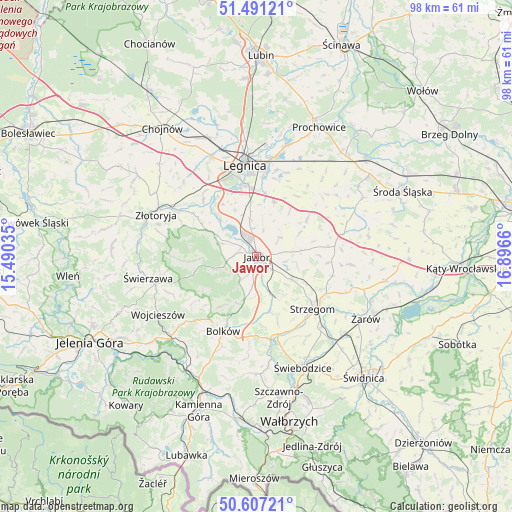
Jawor GPS coordinates[2]
51° 3' 4.752" North, 16° 11' 36.492" East
| Map corner | latitude | longitude |
|---|---|---|
| Upper-left | 51.49121°, | 15.49035° |
| Center: | 51.05132°, | 16.19347° |
| Lower-right: | 50.60721°, | 16.8966° |
| Map W x H: | 98.3×98.3 km | = 61.1×61.1mi |
| max Lat: | 54.83135° ⇑53.9% North |
| Jawor: | 51.05132° |
| min Lat: | ⇓46.1% South 49.21328° |
| min Long | Jawor | max Long |
| 14.20249° | 16.19347° | 24.03723° |
| W 8.6%⇐ | ⇒91.4% E |
Elevation
Elevation of Jawor is 206 m = 676 ft, and this is 14.6 m = 48 ft above average elevation for this country.
| Max E: |
974 m = 3196 ft | 37.8% |
| Jawor | 206 m 676 ft | |
| Avg. | 191.4 m = 628 ft | |
Min E: |
-3 m = -10 ft | 62.2% |
See also: Poland elevation on elevation.city.
Geographical zone
Jawor is located in North temperate zone (between Tropic of Cancer and the Arctic Circle). Distance of this North polar circle is 1724.8 km =1071.7 mi to North.| Distance of | km | miles | from Jawor |
|---|---|---|---|
| North Pole | 4330.7 | 2691 | to North |
| Arctic Circle | 1724.8 | 1071.7 | to North |
| Tropic Cancer | 3070.5 | 1907.9 | to South |
| Equator | 5676.4 | 3527.2 | to South |


Nearby cities:
15 places around Jawor: (largest is in red/bold)
• Bolków
15.8 km =9.8 mi,  204°
204°
• Dobromierz
15.9 km =9.9 mi,  167°
167°
• Konary
13.9 km =8.6 mi,  94°
94°
• Krotoszyce
14.8 km =9.2 mi,  315°
315°
• Legnica
17.8 km =11.1 mi,  352°
352°
• Legnickie Pole
10.9 km =6.8 mi,  18°
18°
• Mierczyce
9.6 km =6 mi,  61°
61°
• Męcinka
7.2 km =4.5 mi,  290°
290°
• Paszowice
5.3 km =3.3 mi,  212°
212°
• Stanowice
18.4 km =11.4 mi,  136°
136°
• Strzegom
14.7 km =9.1 mi,  131°
131°
• Udanin
18.3 km =11.4 mi, 94°
• Wierzchosławice
19.2 km =11.9 mi, 201°
• Wilków
19.1 km =11.9 mi,  283°
283°
• Wądroże Wielkie
12.1 km =7.5 mi,  53°
53°
Sources, notices
• [Note1] Compared only with cities in Poland existing in our database
• [Src1] Map data: © OpenStreetMap contributors (CC-BY-SA)
• [Src2] Other city data from geonames.org with taken over terms of usage.
• [Src3] Geographical zone / Annual Mean Temperature by Robert A. Rohde @ Wikipedia
