Wierzchlas geodata
Wierzchlas (Łódź Voivodeship) is a populated place; located in Poland in Europe/Warsaw (GMT+2) time zone. With population of 2,000 people, there are 1469 cities with bigger population in this country. Compared to other cities in Poland, 51.1% of cities are located further ↓South; 65.5% of cities are located further →East and 61.9% of cities have lower elevation than Wierzchlas. Note1


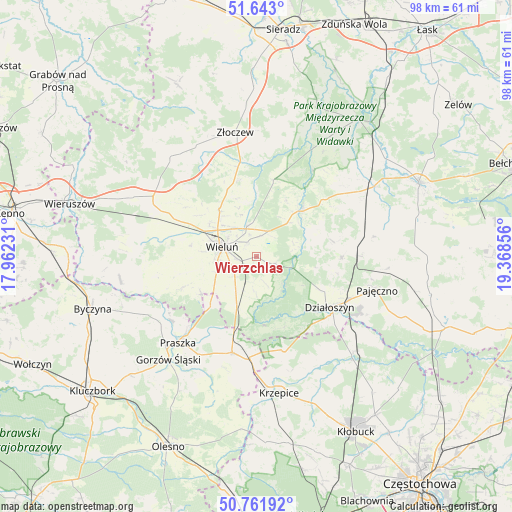
Wierzchlas GPS coordinates[2]
51° 12' 16.452" North, 18° 39' 55.548" East
| Map corner | latitude | longitude |
|---|---|---|
| Upper-left | 51.643°, | 17.96231° |
| Center: | 51.20457°, | 18.66543° |
| Lower-right: | 50.76192°, | 19.36856° |
| Map W x H: | 98×98 km | = 60.9×60.9mi |
| max Lat: | 54.83135° ⇑48.9% North |
| Wierzchlas: | 51.20457° |
| min Lat: | ⇓51.1% South 49.21328° |
| min Long | Wierzchlas | max Long |
| 14.20249° | 18.66543° | 24.03723° |
| W 34.5%⇐ | ⇒65.5% E |
Elevation
Elevation of Wierzchlas is 205 m = 673 ft, and this is 13.6 m = 45 ft above average elevation for this country.
| Max E: |
974 m = 3196 ft | 38.1% |
| Wierzchlas | 205 m 673 ft | |
| Avg. | 191.4 m = 628 ft | |
Min E: |
-3 m = -10 ft | 61.9% |
See also: Poland elevation on elevation.city.
Geographical zone
Wierzchlas is located in North temperate zone (between Tropic of Cancer and the Arctic Circle). Distance of this North polar circle is 1707.8 km =1061.2 mi to North.| Distance of | km | miles | from Wierzchlas |
|---|---|---|---|
| North Pole | 4313.6 | 2680.3 | to North |
| Arctic Circle | 1707.8 | 1061.2 | to North |
| Tropic Cancer | 3087.5 | 1918.5 | to South |
| Equator | 5693.4 | 3537.7 | to South |


Nearby cities:
15 places around Wierzchlas: (largest is in red/bold)
• Czarnożyły
11.6 km =7.2 mi,  321°
321°
• Dalachów
15.4 km =9.6 mi,  203°
203°
• Działoszyn
17 km =10.6 mi,  124°
124°
• Kowale
19.3 km =12 mi,  223°
223°
• Lipnik
14.5 km =9 mi,  77°
77°
• Masłowice
6.1 km =3.8 mi,  341°
341°
• Mokrsko
12.6 km =7.8 mi,  256°
256°
• Osjaków
12.9 km =8 mi,  42°
42°
• Ostrówek
14.9 km =9.3 mi,  348°
348°
• Ożarów
12.6 km =7.8 mi,  238°
238°
• Pątnów
7.5 km =4.7 mi,  206°
206°
• Rudniki
19.1 km =11.9 mi,  194°
194°
• Siemkowice
16.3 km =10.1 mi,  91°
91°
• Wieluń
6.9 km =4.3 mi,  285°
285°
• Wróblew
19.3 km =12 mi,  250°
250°
Sources, notices
• [Note1] Compared only with cities in Poland existing in our database
• [Src1] Map data: © OpenStreetMap contributors (CC-BY-SA)
• [Src2] Other city data from geonames.org with taken over terms of usage.
• [Src3] Geographical zone / Annual Mean Temperature by Robert A. Rohde @ Wikipedia
