Lipka geodata
Lipka (Greater Poland) is a seat of a third-order administrative division; located in Poland in Europe/Warsaw (GMT+2) time zone. With population of 2,200 people, there are 1362 cities with bigger population in this country. Compared to other cities in Poland, 89.5% of cities are located further ↓South; 81.8% of cities are located further →East and 62.1% of cities have higher elevation than Lipka. Note1


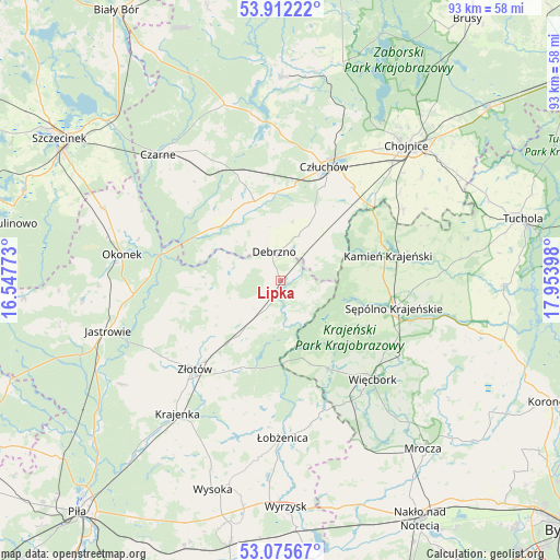
Lipka GPS coordinates[2]
53° 29' 45.636" North, 17° 15' 3.06" East
| Map corner | latitude | longitude |
|---|---|---|
| Upper-left | 53.91222°, | 16.54773° |
| Center: | 53.49601°, | 17.25085° |
| Lower-right: | 53.07567°, | 17.95398° |
| Map W x H: | 93×93 km | = 57.8×57.8mi |
| max Lat: | 54.83135° ⇑10.5% North |
| Lipka: | 53.49601° |
| min Lat: | ⇓89.5% South 49.21328° |
| min Long | Lipka | max Long |
| 14.20249° | 17.25085° | 24.03723° |
| W 18.2%⇐ | ⇒81.8% E |
Elevation
Elevation of Lipka is 142 m = 466 ft, and this is 49.4 m = 162 ft below average elevation for this country.
| Max E: |
974 m = 3196 ft | 62.1% |
| Avg. | 191.4 m = 628 ft | |
| Lipka | 142 m = 466 ft | |
Min E: |
-3 m = -10 ft | 37.9% |
See also: Poland elevation on elevation.city.
Geographical zone
Lipka is located in North temperate zone (between Tropic of Cancer and the Arctic Circle). Distance of this North polar circle is 1453 km =902.9 mi to North.| Distance of | km | miles | from Lipka |
|---|---|---|---|
| North Pole | 4058.9 | 2522.1 | to North |
| Arctic Circle | 1453 | 902.9 | to North |
| Tropic Cancer | 3342.3 | 2076.8 | to South |
| Equator | 5948.2 | 3696 | to South |


Nearby cities:
15 places around Lipka: (largest is in red/bold)
• Chojnice
30 km =18.6 mi,  42°
42°
• Czarne
29.4 km =18.3 mi,  315°
315°
• Człuchów
20.3 km =12.6 mi,  20°
20°
• Debrzno
4.8 km =3 mi,  348°
348°
• Jastrowie
29.9 km =18.6 mi,  253°
253°
• Kamień Krajeński
18.3 km =11.4 mi,  76°
76°
• Krajenka
28 km =17.4 mi,  218°
218°
• Lędyczek
19.6 km =12.2 mi,  283°
283°
• Okonek
26.8 km =16.7 mi, 279°
• Sypniewo
14.9 km =9.3 mi,  160°
160°
• Sępólno Krajeńskie
19.2 km =11.9 mi,  104°
104°
• Więcbork
22.4 km =13.9 mi,  134°
134°
• Zakrzewo
11.3 km =7 mi,  214°
214°
• Złotów
20.3 km =12.6 mi, 223°
• Łobżenica
26 km =16.2 mi,  179°
179°
Sources, notices
• [Note1] Compared only with cities in Poland existing in our database
• [Src1] Map data: © OpenStreetMap contributors (CC-BY-SA)
• [Src2] Other city data from geonames.org with taken over terms of usage.
• [Src3] Geographical zone / Annual Mean Temperature by Robert A. Rohde @ Wikipedia
