Szemud geodata
Szemud (Pomerania) is a seat of a third-order administrative division; located in Poland in Europe/Warsaw (GMT+2) time zone. With population of 1,639 people, there are 1726 cities with bigger population in this country. Compared to other cities in Poland, 98.7% of cities are located further ↓South; 72.2% of cities are located further →East and 51.2% of cities have lower elevation than Szemud. Note1


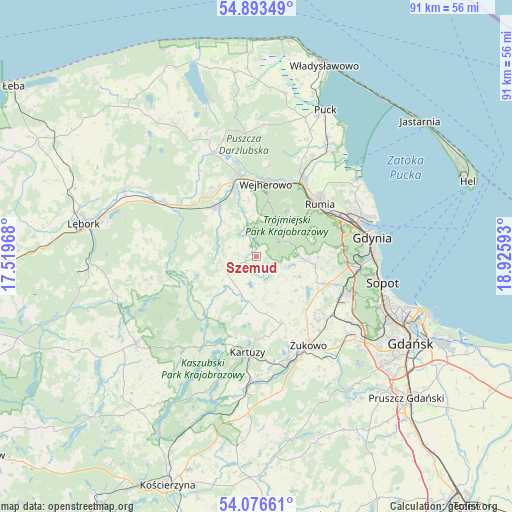
Szemud GPS coordinates[2]
54° 29' 13.524" North, 18° 13' 22.08" East
| Map corner | latitude | longitude |
|---|---|---|
| Upper-left | 54.89349°, | 17.51968° |
| Center: | 54.48709°, | 18.2228° |
| Lower-right: | 54.07661°, | 18.92593° |
| Map W x H: | 90.8×90.8 km | = 56.4×56.4mi |
| max Lat: | 54.83135° ⇑1.3% North |
| Szemud: | 54.48709° |
| min Lat: | ⇓98.7% South 49.21328° |
| min Long | Szemud | max Long |
| 14.20249° | 18.2228° | 24.03723° |
| W 27.8%⇐ | ⇒72.2% E |
Elevation
Elevation of Szemud is 175 m = 574 ft, and this is 16.4 m = 54 ft below average elevation for this country.
| Max E: |
974 m = 3196 ft | 48.8% |
| Avg. | 191.4 m = 628 ft | |
| Szemud | 175 m = 574 ft | |
Min E: |
-3 m = -10 ft | 51.2% |
See also: Poland elevation on elevation.city.
Geographical zone
Szemud is located in North temperate zone (between Tropic of Cancer and the Arctic Circle). Distance of this North polar circle is 1342.8 km =834.4 mi to North.| Distance of | km | miles | from Szemud |
|---|---|---|---|
| North Pole | 3948.7 | 2453.6 | to North |
| Arctic Circle | 1342.8 | 834.4 | to North |
| Tropic Cancer | 3452.5 | 2145.3 | to South |
| Equator | 6058.4 | 3764.5 | to South |


Nearby cities:
15 places around Szemud: (largest is in red/bold)
• Banino
15.9 km =9.9 mi,  131°
131°
• Bojano
10.6 km =6.6 mi,  99°
99°
• Bolszewo
14.9 km =9.3 mi,  348°
348°
• Chwaszczyno
13.5 km =8.4 mi,  110°
110°
• Gościcino
13.8 km =8.6 mi,  341°
341°
• Kartuzy
17.1 km =10.6 mi,  185°
185°
• Koleczkowo
7.8 km =4.8 mi,  90°
90°
• Luzino
11.4 km =7.1 mi,  320°
320°
• Przodkowo
12.6 km =7.8 mi,  160°
160°
• Pępowo
16.6 km =10.3 mi,  140°
140°
• Reda
15.4 km =9.6 mi,  31°
31°
• Rumia
14.2 km =8.8 mi,  48°
48°
• Wejherowo
13.2 km =8.2 mi,  3°
3°
• Wielki Kack
17.3 km =10.7 mi, 97°
• Łapalice
16.8 km =10.4 mi,  201°
201°
Sources, notices
• [Note1] Compared only with cities in Poland existing in our database
• [Src1] Map data: © OpenStreetMap contributors (CC-BY-SA)
• [Src2] Other city data from geonames.org with taken over terms of usage.
• [Src3] Geographical zone / Annual Mean Temperature by Robert A. Rohde @ Wikipedia
