Objazda geodata
Objazda (Pomerania) is a populated place; located in Poland in Europe/Warsaw (GMT+2) time zone. With population of 905 people, there are 2665 cities with bigger population in this country. Compared to other cities in Poland, 99.2% of cities are located further ↓South; 84% of cities are located further →East and 97.9% of cities have higher elevation than Objazda. Note1


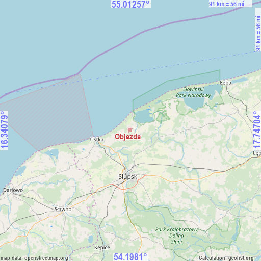
Objazda GPS coordinates[2]
54° 36' 26.532" North, 17° 2' 38.076" East
| Map corner | latitude | longitude |
|---|---|---|
| Upper-left | 55.01257°, | 16.34079° |
| Center: | 54.60737°, | 17.04391° |
| Lower-right: | 54.1981°, | 17.74704° |
| Map W x H: | 90.6×90.6 km | = 56.3×56.3mi |
| max Lat: | 54.83135° ⇑0.8% North |
| Objazda: | 54.60737° |
| min Lat: | ⇓99.2% South 49.21328° |
| min Long | Objazda | max Long |
| 14.20249° | 17.04391° | 24.03723° |
| W 16%⇐ | ⇒84% E |
Elevation
Elevation of Objazda is 15 m = 49 ft, and this is 176.4 m = 579 ft below average elevation for this country.
| Max E: |
974 m = 3196 ft | 97.9% |
| Avg. | 191.4 m = 628 ft | |
| Objazda | 15 m = 49 ft | |
Min E: |
-3 m = -10 ft | 2.1% |
See also: Poland elevation on elevation.city.
Geographical zone
Objazda is located in North temperate zone (between Tropic of Cancer and the Arctic Circle). Distance of this North polar circle is 1329.4 km =826.1 mi to North.| Distance of | km | miles | from Objazda |
|---|---|---|---|
| North Pole | 3935.3 | 2445.3 | to North |
| Arctic Circle | 1329.4 | 826.1 | to North |
| Tropic Cancer | 3465.9 | 2153.6 | to South |
| Equator | 6071.8 | 3772.8 | to South |


Nearby cities:
15 places around Objazda: (largest is in red/bold)
• Barcino
37.1 km =23.1 mi,  188°
188°
• Bobrowniki
20.9 km =13 mi,  115°
115°
• Damnica
18.9 km =11.7 mi,  129°
129°
• Dębnica Kaszubska
26.6 km =16.5 mi,  163°
163°
• Główczyce
21.2 km =13.2 mi,  86°
86°
• Kobylnica
18.9 km =11.7 mi, 189°
• Postomino
24.8 km =15.4 mi,  239°
239°
• Potęgowo
31.7 km =19.7 mi, 115°
• Smołdzino
12.6 km =7.8 mi,  60°
60°
• Sławno
36 km =22.4 mi,  220°
220°
• Słupsk
16 km =9.9 mi,  183°
183°
• Ustka
12.1 km =7.5 mi,  255°
255°
• Wicko
37.6 km =23.4 mi,  79°
79°
• Łeba
37.1 km =23.1 mi, 62°
• Łupawa
31.8 km =19.8 mi, 131°
Sources, notices
• [Note1] Compared only with cities in Poland existing in our database
• [Src1] Map data: © OpenStreetMap contributors (CC-BY-SA)
• [Src2] Other city data from geonames.org with taken over terms of usage.
• [Src3] Geographical zone / Annual Mean Temperature by Robert A. Rohde @ Wikipedia
