Damnica geodata
Damnica (Pomerania) is a seat of a third-order administrative division; located in Poland in Europe/Warsaw (GMT+2) time zone. With population of 1,240 people, there are 2137 cities with bigger population in this country. Compared to other cities in Poland, 98.8% of cities are located further ↓South; 81.6% of cities are located further →East and 92.7% of cities have higher elevation than Damnica. Note1


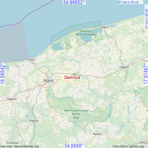
Damnica GPS coordinates[2]
54° 30' 0.9" North, 17° 16' 17.544" East
| Map corner | latitude | longitude |
|---|---|---|
| Upper-left | 54.90652°, | 16.56842° |
| Center: | 54.50025°, | 17.27154° |
| Lower-right: | 54.0899°, | 17.97467° |
| Map W x H: | 90.8×90.8 km | = 56.4×56.4mi |
| max Lat: | 54.83135° ⇑1.2% North |
| Damnica: | 54.50025° |
| min Lat: | ⇓98.8% South 49.21328° |
| min Long | Damnica | max Long |
| 14.20249° | 17.27154° | 24.03723° |
| W 18.4%⇐ | ⇒81.6% E |
Elevation
Elevation of Damnica is 61 m = 200 ft, and this is 130.4 m = 428 ft below average elevation for this country.
| Max E: |
974 m = 3196 ft | 92.7% |
| Avg. | 191.4 m = 628 ft | |
| Damnica | 61 m = 200 ft | |
Min E: |
-3 m = -10 ft | 7.3% |
See also: Poland elevation on elevation.city.
Geographical zone
Damnica is located in North temperate zone (between Tropic of Cancer and the Arctic Circle). Distance of this North polar circle is 1341.3 km =833.4 mi to North.| Distance of | km | miles | from Damnica |
|---|---|---|---|
| North Pole | 3947.2 | 2452.7 | to North |
| Arctic Circle | 1341.3 | 833.4 | to North |
| Tropic Cancer | 3453.9 | 2146.2 | to South |
| Equator | 6059.9 | 3765.4 | to South |


Nearby cities:
15 places around Damnica: (largest is in red/bold)
• Bobrowniki
5.1 km =3.2 mi,  55°
55°
• Czarna Dąbrówka
24.8 km =15.4 mi,  130°
130°
• Dębnica Kaszubska
15.3 km =9.5 mi,  207°
207°
• Główczyce
14.8 km =9.2 mi,  26°
26°
• Kobylnica
18.9 km =11.7 mi,  249°
249°
• Kołczygłowy
29.2 km =18.1 mi,  185°
185°
• Maszewo Lęborskie
30.2 km =18.8 mi,  96°
96°
• Nowa Wieś Lęborska
30.1 km =18.7 mi,  77°
77°
• Objazda
18.9 km =11.7 mi,  309°
309°
• Potęgowo
14 km =8.7 mi, 97°
• Smołdzino
18.5 km =11.5 mi,  348°
348°
• Słupsk
16.2 km =10.1 mi,  255°
255°
• Ustka
27.9 km =17.3 mi,  288°
288°
• Wicko
29.3 km =18.2 mi,  49°
49°
• Łupawa
13 km =8.1 mi, 134°
Sources, notices
• [Note1] Compared only with cities in Poland existing in our database
• [Src1] Map data: © OpenStreetMap contributors (CC-BY-SA)
• [Src2] Other city data from geonames.org with taken over terms of usage.
• [Src3] Geographical zone / Annual Mean Temperature by Robert A. Rohde @ Wikipedia
