Smołdzino geodata
Smołdzino (Pomerania) is a seat of a third-order administrative division; located in Poland in Europe/Warsaw (GMT+2) time zone. With population of 984 people, there are 2527 cities with bigger population in this country. Compared to other cities in Poland, 99.5% of cities are located further ↓South; 82.1% of cities are located further →East and 98.9% of cities have higher elevation than Smołdzino. Note1


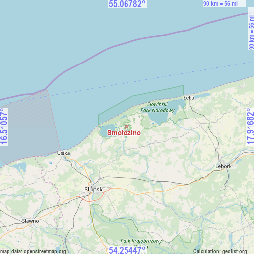
Smołdzino GPS coordinates[2]
54° 39' 47.448" North, 17° 12' 49.284" East
| Map corner | latitude | longitude |
|---|---|---|
| Upper-left | 55.06782°, | 16.51057° |
| Center: | 54.66318°, | 17.21369° |
| Lower-right: | 54.25447°, | 17.91682° |
| Map W x H: | 90.4×90.4 km | = 56.2×56.2mi |
| max Lat: | 54.83135° ⇑0.5% North |
| Smołdzino: | 54.66318° |
| min Lat: | ⇓99.5% South 49.21328° |
| min Long | Smołdzino | max Long |
| 14.20249° | 17.21369° | 24.03723° |
| W 17.9%⇐ | ⇒82.1% E |
Elevation
Elevation of Smołdzino is 5 m = 16 ft, and this is 186.4 m = 612 ft below average elevation for this country.
| Max E: |
974 m = 3196 ft | 98.9% |
| Avg. | 191.4 m = 628 ft | |
| Smołdzino | 5 m = 16 ft | |
Min E: |
-3 m = -10 ft | 1.1% |
See also: Poland elevation on elevation.city.
Geographical zone
Smołdzino is located in North temperate zone (between Tropic of Cancer and the Arctic Circle). Distance of this North polar circle is 1323.2 km =822.2 mi to North.| Distance of | km | miles | from Smołdzino |
|---|---|---|---|
| North Pole | 3929.1 | 2441.4 | to North |
| Arctic Circle | 1323.2 | 822.2 | to North |
| Tropic Cancer | 3472.1 | 2157.5 | to South |
| Equator | 6078 | 3776.7 | to South |


Nearby cities:
15 places around Smołdzino: (largest is in red/bold)
• Bobrowniki
17.1 km =10.6 mi,  152°
152°
• Damnica
18.5 km =11.5 mi,  168°
168°
• Dębnica Kaszubska
31.9 km =19.8 mi,  186°
186°
• Główczyce
11.3 km =7 mi,  115°
115°
• Kobylnica
28.5 km =17.7 mi,  209°
209°
• Lębork
37.2 km =23.1 mi,  111°
111°
• Nowa Wieś Lęborska
35.1 km =21.8 mi, 109°
• Objazda
12.6 km =7.8 mi,  240°
240°
• Postomino
37.3 km =23.2 mi, 239°
• Potęgowo
26.7 km =16.6 mi,  138°
138°
• Słupsk
25.1 km =15.6 mi, 208°
• Ustka
24.4 km =15.2 mi,  247°
247°
• Wicko
26 km =16.2 mi,  88°
88°
• Łeba
24.5 km =15.2 mi,  63°
63°
• Łupawa
30.1 km =18.7 mi, 154°
Sources, notices
• [Note1] Compared only with cities in Poland existing in our database
• [Src1] Map data: © OpenStreetMap contributors (CC-BY-SA)
• [Src2] Other city data from geonames.org with taken over terms of usage.
• [Src3] Geographical zone / Annual Mean Temperature by Robert A. Rohde @ Wikipedia
