Twardogóra geodata
Twardogóra (Lower Silesia) is a populated place; located in Poland in Europe/Warsaw (GMT+2) time zone. With population of 6,840 people, there are 550 cities with bigger population in this country. Compared to other cities in Poland, 54.3% of cities are located further ↓South; 80.2% of cities are located further →East and 53.5% of cities have lower elevation than Twardogóra. Note1


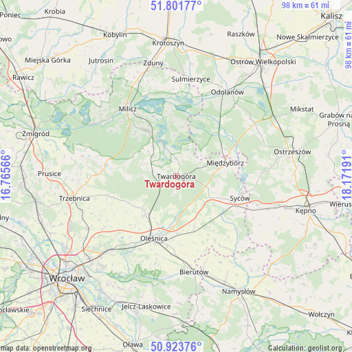
Twardogóra GPS coordinates[2]
51° 21' 53.532" North, 17° 28' 7.608" East
| Map corner | latitude | longitude |
|---|---|---|
| Upper-left | 51.80177°, | 16.76566° |
| Center: | 51.36487°, | 17.46878° |
| Lower-right: | 50.92376°, | 18.17191° |
| Map W x H: | 97.6×97.6 km | = 60.6×60.6mi |
| max Lat: | 54.83135° ⇑45.7% North |
| Twardogóra: | 51.36487° |
| min Lat: | ⇓54.3% South 49.21328° |
| min Long | Twardogóra | max Long |
| 14.20249° | 17.46878° | 24.03723° |
| W 19.8%⇐ | ⇒80.2% E |
Elevation
Elevation of Twardogóra is 181 m = 594 ft, and this is 10.4 m = 34 ft below average elevation for this country.
| Max E: |
974 m = 3196 ft | 46.5% |
| Avg. | 191.4 m = 628 ft | |
| Twardogóra | 181 m = 594 ft | |
Min E: |
-3 m = -10 ft | 53.5% |
See also: Poland elevation on elevation.city.
Geographical zone
Twardogóra is located in North temperate zone (between Tropic of Cancer and the Arctic Circle). Distance of this North polar circle is 1689.9 km =1050.1 mi to North.| Distance of | km | miles | from Twardogóra |
|---|---|---|---|
| North Pole | 4295.8 | 2669.3 | to North |
| Arctic Circle | 1689.9 | 1050.1 | to North |
| Tropic Cancer | 3105.3 | 1929.5 | to South |
| Equator | 5711.2 | 3548.8 | to South |


Nearby cities:
15 places around Twardogóra: (largest is in red/bold)
• Cielętniki
19.6 km =12.2 mi,  247°
247°
• Dobroszyce
13.9 km =8.6 mi,  219°
219°
• Dziadowa Kłoda
22.1 km =13.7 mi,  130°
130°
• Garki
22.7 km =14.1 mi,  32°
32°
• Kobyla Góra
25.7 km =16 mi,  86°
86°
• Krośnice
14.5 km =9 mi,  328°
328°
• Miechów
24.7 km =15.3 mi,  119°
119°
• Milicz
22.7 km =14.1 mi,  322°
322°
• Międzybórz
14.1 km =8.8 mi,  75°
75°
• Oleśnica
17.7 km =11 mi,  198°
198°
• Perzów
25.7 km =16 mi,  112°
112°
• Solniki Wielkie
22.3 km =13.9 mi,  179°
179°
• Sośnie
16.6 km =10.3 mi,  43°
43°
• Syców
18.5 km =11.5 mi, 109°
• Zawonia
19.5 km =12.1 mi, 253°
Sources, notices
• [Note1] Compared only with cities in Poland existing in our database
• [Src1] Map data: © OpenStreetMap contributors (CC-BY-SA)
• [Src2] Other city data from geonames.org with taken over terms of usage.
• [Src3] Geographical zone / Annual Mean Temperature by Robert A. Rohde @ Wikipedia
