Zawonia geodata
Zawonia (Lower Silesia) is a populated place; located in Poland in Europe/Warsaw (GMT+2) time zone. With population of 920 people, there are 2637 cities with bigger population in this country. Compared to other cities in Poland, 53.5% of cities are located further ↓South; 82.2% of cities are located further →East and 54.5% of cities have higher elevation than Zawonia. Note1


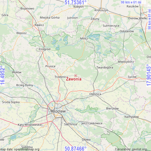
Zawonia GPS coordinates[2]
51° 18' 58.464" North, 17° 11' 53.952" East
| Map corner | latitude | longitude |
|---|---|---|
| Upper-left | 51.75361°, | 16.4952° |
| Center: | 51.31624°, | 17.19832° |
| Lower-right: | 50.87466°, | 17.90145° |
| Map W x H: | 97.7×97.7 km | = 60.7×60.7mi |
| max Lat: | 54.83135° ⇑46.5% North |
| Zawonia: | 51.31624° |
| min Lat: | ⇓53.5% South 49.21328° |
| min Long | Zawonia | max Long |
| 14.20249° | 17.19832° | 24.03723° |
| W 17.8%⇐ | ⇒82.2% E |
Elevation
Elevation of Zawonia is 160 m = 525 ft, and this is 31.4 m = 103 ft below average elevation for this country.
| Max E: |
974 m = 3196 ft | 54.5% |
| Avg. | 191.4 m = 628 ft | |
| Zawonia | 160 m = 525 ft | |
Min E: |
-3 m = -10 ft | 45.5% |
See also: Poland elevation on elevation.city.
Geographical zone
Zawonia is located in North temperate zone (between Tropic of Cancer and the Arctic Circle). Distance of this North polar circle is 1695.3 km =1053.4 mi to North.| Distance of | km | miles | from Zawonia |
|---|---|---|---|
| North Pole | 4301.2 | 2672.6 | to North |
| Arctic Circle | 1695.3 | 1053.4 | to North |
| Tropic Cancer | 3099.9 | 1926.2 | to South |
| Equator | 5705.8 | 3545.4 | to South |


Nearby cities:
15 places around Zawonia: (largest is in red/bold)
• Cielętniki
2.2 km =1.4 mi,  161°
161°
• Dobroszyce
11.4 km =7.1 mi,  118°
118°
• Długołęka
15.3 km =9.5 mi,  181°
181°
• Mirków
17.4 km =10.8 mi,  186°
186°
• Oleśnica
17.6 km =10.9 mi,  130°
130°
• Pawłowice-Kłokoczyce
18.2 km =11.3 mi,  202°
202°
• Prusice
17.6 km =10.9 mi,  290°
290°
• Psary
18.5 km =11.5 mi,  218°
218°
• Psie Pole Południe-Kiełczów
19.4 km =12.1 mi, 194°
• Psie Pole Północ
19.2 km =11.9 mi, 198°
• Szczodre
13.5 km =8.4 mi, 184°
• Trzebnica
9.4 km =5.8 mi,  266°
266°
• Twardogóra
19.5 km =12.1 mi,  73°
73°
• Wisznia Mała
13.1 km =8.1 mi,  234°
234°
• Zakrzów
17.2 km =10.7 mi, 194°
Sources, notices
• [Note1] Compared only with cities in Poland existing in our database
• [Src1] Map data: © OpenStreetMap contributors (CC-BY-SA)
• [Src2] Other city data from geonames.org with taken over terms of usage.
• [Src3] Geographical zone / Annual Mean Temperature by Robert A. Rohde @ Wikipedia
