Dobroszyce geodata
Dobroszyce (Lower Silesia) is a populated place; located in Poland in Europe/Warsaw (GMT+2) time zone. With population of 2,376 people, there are 1296 cities with bigger population in this country. Compared to other cities in Poland, 52.5% of cities are located further ↓South; 81.1% of cities are located further →East and 53.7% of cities have higher elevation than Dobroszyce. Note1


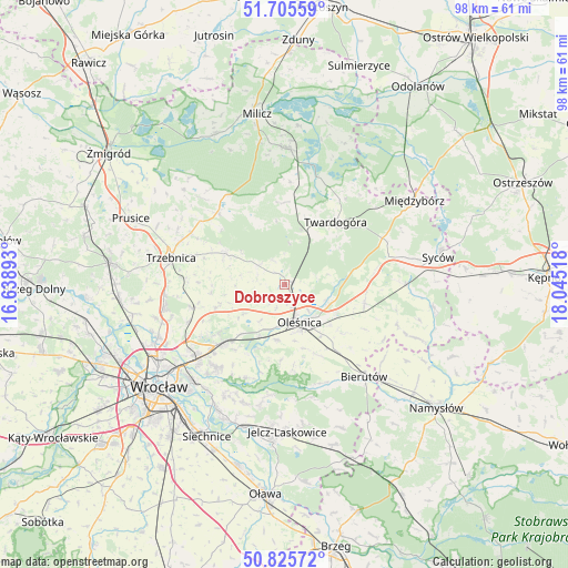
Dobroszyce GPS coordinates[2]
51° 16' 3.936" North, 17° 20' 31.38" East
| Map corner | latitude | longitude |
|---|---|---|
| Upper-left | 51.70559°, | 16.63893° |
| Center: | 51.26776°, | 17.34205° |
| Lower-right: | 50.82572°, | 18.04518° |
| Map W x H: | 97.8×97.8 km | = 60.8×60.8mi |
| max Lat: | 54.83135° ⇑47.5% North |
| Dobroszyce: | 51.26776° |
| min Lat: | ⇓52.5% South 49.21328° |
| min Long | Dobroszyce | max Long |
| 14.20249° | 17.34205° | 24.03723° |
| W 18.9%⇐ | ⇒81.1% E |
Elevation
Elevation of Dobroszyce is 162 m = 531 ft, and this is 29.4 m = 96 ft below average elevation for this country.
| Max E: |
974 m = 3196 ft | 53.7% |
| Avg. | 191.4 m = 628 ft | |
| Dobroszyce | 162 m = 531 ft | |
Min E: |
-3 m = -10 ft | 46.3% |
See also: Poland elevation on elevation.city.
Geographical zone
Dobroszyce is located in North temperate zone (between Tropic of Cancer and the Arctic Circle). Distance of this North polar circle is 1700.7 km =1056.8 mi to North.| Distance of | km | miles | from Dobroszyce |
|---|---|---|---|
| North Pole | 4306.6 | 2676 | to North |
| Arctic Circle | 1700.7 | 1056.8 | to North |
| Tropic Cancer | 3094.5 | 1922.8 | to South |
| Equator | 5700.4 | 3542.1 | to South |


Nearby cities:
15 places around Dobroszyce: (largest is in red/bold)
• Cielętniki
9.9 km =6.2 mi,  289°
289°
• Długołęka
14.4 km =8.9 mi,  226°
226°
• Kiełczów
18.2 km =11.3 mi,  218°
218°
• Mirków
16.9 km =10.5 mi, 225°
• Oleśnica
6.9 km =4.3 mi,  151°
151°
• Pawłowice-Kłokoczyce
20.5 km =12.7 mi,  236°
236°
• Psie Pole Południe-Kiełczów
20 km =12.4 mi, 228°
• Solniki Wielkie
14.7 km =9.1 mi,  141°
141°
• Szczodre
13.7 km =8.5 mi, 233°
• Trzebnica
20 km =12.4 mi,  283°
283°
• Twardogóra
13.9 km =8.6 mi,  39°
39°
• Wilczyce
20.2 km =12.6 mi, 220°
• Zakrzów
18.2 km =11.3 mi, 231°
• Zawonia
11.4 km =7.1 mi,  298°
298°
• Zgorzelisko
20.4 km =12.7 mi, 225°
Sources, notices
• [Note1] Compared only with cities in Poland existing in our database
• [Src1] Map data: © OpenStreetMap contributors (CC-BY-SA)
• [Src2] Other city data from geonames.org with taken over terms of usage.
• [Src3] Geographical zone / Annual Mean Temperature by Robert A. Rohde @ Wikipedia
