Poborszów geodata
Poborszów (Opole Voivodeship) is a populated place; located in Poland in Europe/Warsaw (GMT+2) time zone. With population of 621 people, there are 3224 cities with bigger population in this country. Compared to other cities in Poland, 70.1% of cities are located further ↑North; 74.5% of cities are located further →East and 50.2% of cities have higher elevation than Poborszów. Note1
Administrative division(s):
- Level 1: Opole Voivodeship
- Level 2: Powiat kędzierzyńsko-kozielski
- Level 3: Reńska Wieś


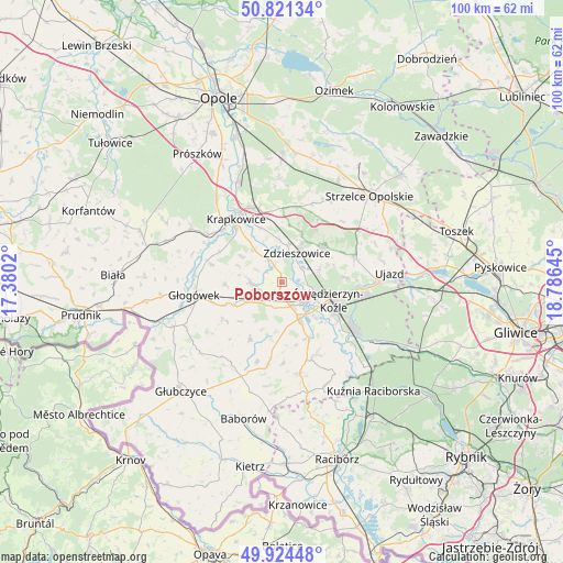
Poborszów GPS coordinates[2]
50° 22' 30.108" North, 18° 4' 59.952" East
| Map corner | latitude | longitude |
|---|---|---|
| Upper-left | 50.82134°, | 17.3802° |
| Center: | 50.37503°, | 18.08332° |
| Lower-right: | 49.92448°, | 18.78645° |
| Map W x H: | 99.7×99.7 km | = 62×62mi |
| max Lat: | 54.83135° ⇑70.1% North |
| Poborszów: | 50.37503° |
| min Lat: | ⇓29.9% South 49.21328° |
| min Long | Poborszów | max Long |
| 14.20249° | 18.08332° | 24.03723° |
| W 25.5%⇐ | ⇒74.5% E |
Elevation
Elevation of Poborszów is 171 m = 561 ft, and this is 20.4 m = 67 ft below average elevation for this country.
| Max E: |
974 m = 3196 ft | 50.2% |
| Avg. | 191.4 m = 628 ft | |
| Poborszów | 171 m = 561 ft | |
Min E: |
-3 m = -10 ft | 49.8% |
See also: Poland elevation on elevation.city.
Geographical zone
Poborszów is located in North temperate zone (between Tropic of Cancer and the Arctic Circle). Distance of this North polar circle is 1800 km =1118.5 mi to North.| Distance of | km | miles | from Poborszów |
|---|---|---|---|
| North Pole | 4405.9 | 2737.7 | to North |
| Arctic Circle | 1800 | 1118.5 | to North |
| Tropic Cancer | 2995.3 | 1861.2 | to South |
| Equator | 5601.2 | 3480.4 | to South |


Nearby cities:
15 places around Poborszów: (largest is in red/bold)
• Dobieszowice
4.3 km =2.7 mi,  251°
251°
• Januszkowice
4.2 km =2.6 mi,  63°
63°
• Komorno
2.1 km =1.3 mi,  197°
197°
• Koźle
6.1 km =3.8 mi,  135°
135°
• Kędzierzyn-Koźle
10.5 km =6.5 mi,  105°
105°
• Leśnica
9.6 km =6 mi,  49°
49°
• Pokrzywnica
4.9 km =3 mi, 197°
• Raszowa
7.1 km =4.4 mi,  69°
69°
• Reńska Wieś
7.2 km =4.5 mi,  155°
155°
• Rozkochów
10.2 km =6.3 mi,  267°
267°
• Rozwadza
6.8 km =4.2 mi,  9°
9°
• Twardawa
7.4 km =4.6 mi,  241°
241°
• Walce
5.6 km =3.5 mi, 267°
• Większyce
4.5 km =2.8 mi, 162°
• Zdzieszowice
6.2 km =3.9 mi,  27°
27°
Sources, notices
• [Note1] Compared only with cities in Poland existing in our database
• [Src1] Map data: © OpenStreetMap contributors (CC-BY-SA)
• [Src2] Other city data from geonames.org with taken over terms of usage.
• [Src3] Geographical zone / Annual Mean Temperature by Robert A. Rohde @ Wikipedia
