Walce geodata
Walce (Opole Voivodeship) is a seat of a third-order administrative division; located in Poland in Europe/Warsaw (GMT+2) time zone. With population of 2,100 people, there are 1411 cities with bigger population in this country. Compared to other cities in Poland, 70.3% of cities are located further ↑North; 75.2% of cities are located further →East and 53.8% of cities have lower elevation than Walce. Note1


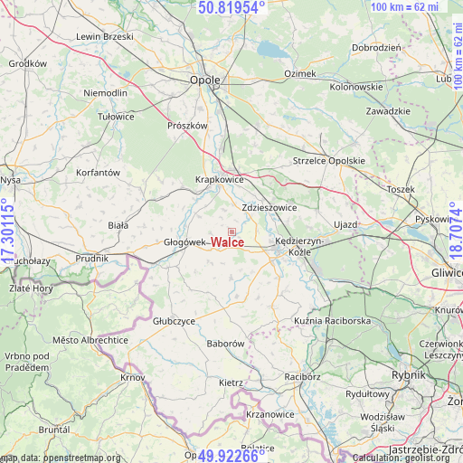
Walce GPS coordinates[2]
50° 22' 23.592" North, 18° 0' 15.372" East
| Map corner | latitude | longitude |
|---|---|---|
| Upper-left | 50.81954°, | 17.30115° |
| Center: | 50.37322°, | 18.00427° |
| Lower-right: | 49.92266°, | 18.7074° |
| Map W x H: | 99.7×99.7 km | = 62×62mi |
| max Lat: | 54.83135° ⇑70.3% North |
| Walce: | 50.37322° |
| min Lat: | ⇓29.7% South 49.21328° |
| min Long | Walce | max Long |
| 14.20249° | 18.00427° | 24.03723° |
| W 24.8%⇐ | ⇒75.2% E |
Elevation
Elevation of Walce is 182 m = 597 ft, and this is 9.4 m = 31 ft below average elevation for this country.
| Max E: |
974 m = 3196 ft | 46.2% |
| Avg. | 191.4 m = 628 ft | |
| Walce | 182 m = 597 ft | |
Min E: |
-3 m = -10 ft | 53.8% |
See also: Poland elevation on elevation.city.
Geographical zone
Walce is located in North temperate zone (between Tropic of Cancer and the Arctic Circle). Distance of this North polar circle is 1800.2 km =1118.6 mi to North.| Distance of | km | miles | from Walce |
|---|---|---|---|
| North Pole | 4406.1 | 2737.8 | to North |
| Arctic Circle | 1800.2 | 1118.6 | to North |
| Tropic Cancer | 2995.1 | 1861.1 | to South |
| Equator | 5601 | 3480.3 | to South |


Nearby cities:
15 places around Walce: (largest is in red/bold)
• Dobieszowice
1.9 km =1.2 mi,  127°
127°
• Dobra
11.1 km =6.9 mi,  321°
321°
• Głogówek
10.2 km =6.3 mi,  257°
257°
• Januszkowice
9.6 km =6 mi,  77°
77°
• Komorno
5.3 km =3.3 mi,  109°
109°
• Koźle
10.7 km =6.6 mi, 112°
• Kórnica
7.8 km =4.8 mi,  296°
296°
• Poborszów
5.6 km =3.5 mi,  87°
87°
• Pokrzywnica
6.1 km =3.8 mi,  137°
137°
• Reńska Wieś
10.7 km =6.6 mi, 126°
• Rozkochów
4.5 km =2.8 mi,  266°
266°
• Rozwadza
9.6 km =6 mi,  44°
44°
• Twardawa
3.4 km =2.1 mi,  195°
195°
• Większyce
8.1 km =5 mi,  120°
120°
• Zdzieszowice
10.2 km =6.3 mi,  55°
55°
Sources, notices
• [Note1] Compared only with cities in Poland existing in our database
• [Src1] Map data: © OpenStreetMap contributors (CC-BY-SA)
• [Src2] Other city data from geonames.org with taken over terms of usage.
• [Src3] Geographical zone / Annual Mean Temperature by Robert A. Rohde @ Wikipedia
