Dobieszowice geodata
Dobieszowice (Opole Voivodeship) is a populated place; located in Poland in Europe/Warsaw (GMT+2) time zone. With population of 614 people, there are 3242 cities with bigger population in this country. Compared to other cities in Poland, 70.5% of cities are located further ↑North; 74.9% of cities are located further →East and 52.6% of cities have lower elevation than Dobieszowice. Note1


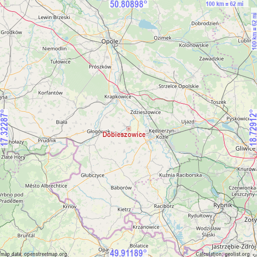
Dobieszowice GPS coordinates[2]
50° 21' 45.18" North, 18° 1' 33.564" East
| Map corner | latitude | longitude |
|---|---|---|
| Upper-left | 50.80898°, | 17.32287° |
| Center: | 50.36255°, | 18.02599° |
| Lower-right: | 49.91189°, | 18.72912° |
| Map W x H: | 99.7×99.7 km | = 62×62mi |
| max Lat: | 54.83135° ⇑70.5% North |
| Dobieszowice: | 50.36255° |
| min Lat: | ⇓29.5% South 49.21328° |
| min Long | Dobieszowice | max Long |
| 14.20249° | 18.02599° | 24.03723° |
| W 25.1%⇐ | ⇒74.9% E |
Elevation
Elevation of Dobieszowice is 179 m = 587 ft, and this is 12.4 m = 41 ft below average elevation for this country.
| Max E: |
974 m = 3196 ft | 47.4% |
| Avg. | 191.4 m = 628 ft | |
| Dobieszowice | 179 m = 587 ft | |
Min E: |
-3 m = -10 ft | 52.6% |
See also: Poland elevation on elevation.city.
Geographical zone
Dobieszowice is located in North temperate zone (between Tropic of Cancer and the Arctic Circle). Distance of this North polar circle is 1801.4 km =1119.3 mi to North.| Distance of | km | miles | from Dobieszowice |
|---|---|---|---|
| North Pole | 4407.3 | 2738.6 | to North |
| Arctic Circle | 1801.4 | 1119.3 | to North |
| Tropic Cancer | 2993.9 | 1860.3 | to South |
| Equator | 5599.8 | 3479.6 | to South |


Nearby cities:
15 places around Dobieszowice: (largest is in red/bold)
• Głogówek
11.5 km =7.1 mi,  265°
265°
• Januszkowice
8.5 km =5.3 mi,  67°
67°
• Komorno
3.5 km =2.2 mi,  99°
99°
• Koźle
8.8 km =5.5 mi,  109°
109°
• Kórnica
9.7 km =6 mi,  298°
298°
• Poborszów
4.3 km =2.7 mi, 71°
• Pokrzywnica
4.2 km =2.6 mi,  142°
142°
• Raszowa
11.4 km =7.1 mi, 69°
• Reńska Wieś
8.8 km =5.5 mi,  126°
126°
• Rozkochów
6.1 km =3.8 mi,  278°
278°
• Rozwadza
9.6 km =6 mi,  33°
33°
• Twardawa
3.3 km =2.1 mi,  229°
229°
• Walce
1.9 km =1.2 mi,  307°
307°
• Większyce
6.1 km =3.8 mi,  118°
118°
• Zdzieszowice
9.8 km =6.1 mi,  44°
44°
Sources, notices
• [Note1] Compared only with cities in Poland existing in our database
• [Src1] Map data: © OpenStreetMap contributors (CC-BY-SA)
• [Src2] Other city data from geonames.org with taken over terms of usage.
• [Src3] Geographical zone / Annual Mean Temperature by Robert A. Rohde @ Wikipedia
