Trzebnica geodata
Trzebnica (Lower Silesia) is a populated place; located in Poland in Europe/Warsaw (GMT+2) time zone. With population of 12,212 people, there are 390 cities with bigger population in this country. Compared to other cities in Poland, 53.4% of cities are located further ↓South; 83.7% of cities are located further →East and 53.5% of cities have lower elevation than Trzebnica. Note1


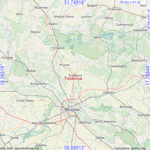
Trzebnica GPS coordinates[2]
51° 18' 38.736" North, 17° 3' 47.916" East
| Map corner | latitude | longitude |
|---|---|---|
| Upper-left | 51.74818°, | 16.36019° |
| Center: | 51.31076°, | 17.06331° |
| Lower-right: | 50.86913°, | 17.76644° |
| Map W x H: | 97.7×97.7 km | = 60.7×60.7mi |
| max Lat: | 54.83135° ⇑46.6% North |
| Trzebnica: | 51.31076° |
| min Lat: | ⇓53.4% South 49.21328° |
| min Long | Trzebnica | max Long |
| 14.20249° | 17.06331° | 24.03723° |
| W 16.3%⇐ | ⇒83.7% E |
Elevation
Elevation of Trzebnica is 181 m = 594 ft, and this is 10.4 m = 34 ft below average elevation for this country.
| Max E: |
974 m = 3196 ft | 46.5% |
| Avg. | 191.4 m = 628 ft | |
| Trzebnica | 181 m = 594 ft | |
Min E: |
-3 m = -10 ft | 53.5% |
See also: Poland elevation on elevation.city.
Geographical zone
Trzebnica is located in North temperate zone (between Tropic of Cancer and the Arctic Circle). Distance of this North polar circle is 1696 km =1053.8 mi to North.| Distance of | km | miles | from Trzebnica |
|---|---|---|---|
| North Pole | 4301.8 | 2673 | to North |
| Arctic Circle | 1696 | 1053.8 | to North |
| Tropic Cancer | 3099.3 | 1925.8 | to South |
| Equator | 5705.2 | 3545 | to South |


Nearby cities:
15 places around Trzebnica: (largest is in red/bold)
• Cielętniki
10.2 km =6.3 mi,  98°
98°
• Długołęka
17.1 km =10.6 mi,  148°
148°
• Oborniki Śląskie
10.4 km =6.5 mi,  264°
264°
• Pawłowice-Kłokoczyce
16.4 km =10.2 mi,  171°
171°
• Poświętne
17.3 km =10.7 mi,  187°
187°
• Pracze Odrzańskie-Janówek
17.4 km =10.8 mi,  218°
218°
• Prusice
9.8 km =6.1 mi,  313°
313°
• Psary
13.9 km =8.6 mi, 189°
• Sołtysowice
17.6 km =10.9 mi,  178°
178°
• Szczodre
15.3 km =9.5 mi, 147°
• Uraz
16.2 km =10.1 mi,  245°
245°
• Widawa-Lipa Piotrowska-Polanowice
15.8 km =9.8 mi, 190°
• Wisznia Mała
7.1 km =4.4 mi, 190°
• Zakrzów
16.9 km =10.5 mi,  162°
162°
• Zawonia
9.4 km =5.8 mi,  86°
86°
Sources, notices
• [Note1] Compared only with cities in Poland existing in our database
• [Src1] Map data: © OpenStreetMap contributors (CC-BY-SA)
• [Src2] Other city data from geonames.org with taken over terms of usage.
• [Src3] Geographical zone / Annual Mean Temperature by Robert A. Rohde @ Wikipedia
