Prusice geodata
Prusice (Lower Silesia) is a populated place; located in Poland in Europe/Warsaw (GMT+2) time zone. With population of 2,203 people, there are 1361 cities with bigger population in this country. Compared to other cities in Poland, 54.5% of cities are located further ↓South; 85.3% of cities are located further →East and 72.1% of cities have higher elevation than Prusice. Note1


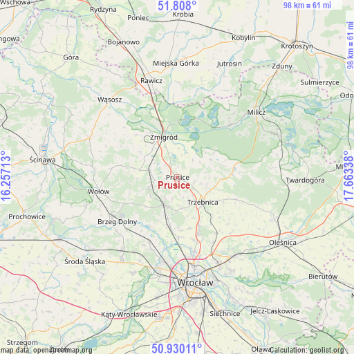
Prusice GPS coordinates[2]
51° 22' 16.176" North, 16° 57' 36.9" East
| Map corner | latitude | longitude |
|---|---|---|
| Upper-left | 51.808°, | 16.25713° |
| Center: | 51.37116°, | 16.96025° |
| Lower-right: | 50.93011°, | 17.66338° |
| Map W x H: | 97.6×97.6 km | = 60.6×60.6mi |
| max Lat: | 54.83135° ⇑45.5% North |
| Prusice: | 51.37116° |
| min Lat: | ⇓54.5% South 49.21328° |
| min Long | Prusice | max Long |
| 14.20249° | 16.96025° | 24.03723° |
| W 14.7%⇐ | ⇒85.3% E |
Elevation
Elevation of Prusice is 117 m = 384 ft, and this is 74.4 m = 244 ft below average elevation for this country.
| Max E: |
974 m = 3196 ft | 72.1% |
| Avg. | 191.4 m = 628 ft | |
| Prusice | 117 m = 384 ft | |
Min E: |
-3 m = -10 ft | 27.9% |
See also: Poland elevation on elevation.city.
Geographical zone
Prusice is located in North temperate zone (between Tropic of Cancer and the Arctic Circle). Distance of this North polar circle is 1689.2 km =1049.6 mi to North.| Distance of | km | miles | from Prusice |
|---|---|---|---|
| North Pole | 4295.1 | 2668.9 | to North |
| Arctic Circle | 1689.2 | 1049.6 | to North |
| Tropic Cancer | 3106 | 1930 | to South |
| Equator | 5711.9 | 3549.2 | to South |


Nearby cities:
15 places around Prusice: (largest is in red/bold)
• Brzeg Dolny
20.6 km =12.8 mi,  238°
238°
• Cielętniki
19.1 km =11.9 mi,  115°
115°
• Marszowice
22.8 km =14.2 mi,  193°
193°
• Maślice Wielkie
23.2 km =14.4 mi, 185°
• Oborniki Śląskie
8.4 km =5.2 mi,  202°
202°
• Pracze Odrzańskie-Janówek
20.7 km =12.9 mi, 190°
• Psary
21.1 km =13.1 mi,  166°
166°
• Sułów
20.3 km =12.6 mi,  45°
45°
• Trzebnica
9.8 km =6.1 mi,  133°
133°
• Uraz
15.5 km =9.6 mi,  209°
209°
• Widawa-Lipa Piotrowska-Polanowice
22.7 km =14.1 mi, 169°
• Wisznia Mała
15 km =9.3 mi,  156°
156°
• Wołów
22.3 km =13.9 mi,  260°
260°
• Zawonia
17.6 km =10.9 mi,  110°
110°
• Żmigród
11.3 km =7 mi,  340°
340°
Sources, notices
• [Note1] Compared only with cities in Poland existing in our database
• [Src1] Map data: © OpenStreetMap contributors (CC-BY-SA)
• [Src2] Other city data from geonames.org with taken over terms of usage.
• [Src3] Geographical zone / Annual Mean Temperature by Robert A. Rohde @ Wikipedia
