Torzym geodata
Torzym (Lubusz) is a seat of a third-order administrative division; located in Poland in Europe/Warsaw (GMT+2) time zone. With population of 2,466 people, there are 1262 cities with bigger population in this country. Compared to other cities in Poland, 72.9% of cities are located further ↓South; 97.4% of cities are located further →East and 82.7% of cities have higher elevation than Torzym. Note1


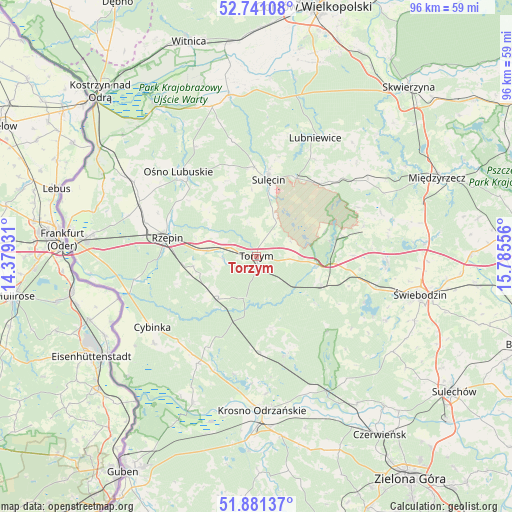
Torzym GPS coordinates[2]
52° 18' 47.916" North, 15° 4' 56.748" East
| Map corner | latitude | longitude |
|---|---|---|
| Upper-left | 52.74108°, | 14.37931° |
| Center: | 52.31331°, | 15.08243° |
| Lower-right: | 51.88137°, | 15.78556° |
| Map W x H: | 95.6×95.6 km | = 59.4×59.4mi |
| max Lat: | 54.83135° ⇑27.1% North |
| Torzym: | 52.31331° |
| min Lat: | ⇓72.9% South 49.21328° |
| min Long | Torzym | max Long |
| 14.20249° | 15.08243° | 24.03723° |
| W 2.6%⇐ | ⇒97.4% E |
Elevation
Elevation of Torzym is 94 m = 308 ft, and this is 97.4 m = 320 ft below average elevation for this country.
| Max E: |
974 m = 3196 ft | 82.7% |
| Avg. | 191.4 m = 628 ft | |
| Torzym | 94 m = 308 ft | |
Min E: |
-3 m = -10 ft | 17.3% |
See also: Poland elevation on elevation.city.
Geographical zone
Torzym is located in North temperate zone (between Tropic of Cancer and the Arctic Circle). Distance of this North polar circle is 1584.5 km =984.6 mi to North.| Distance of | km | miles | from Torzym |
|---|---|---|---|
| North Pole | 4190.4 | 2603.8 | to North |
| Arctic Circle | 1584.5 | 984.6 | to North |
| Tropic Cancer | 3210.8 | 1995.1 | to South |
| Equator | 5816.7 | 3614.3 | to South |


Nearby cities:
15 places around Torzym: (largest is in red/bold)
• Boczów
9.3 km =5.8 mi,  276°
276°
• Bytnica
19 km =11.8 mi,  161°
161°
• Cybinka
23.6 km =14.7 mi,  235°
235°
• Glisno
21.1 km =13.1 mi,  30°
30°
• Krosno Odrzańskie
28.8 km =17.9 mi,  177°
177°
• Lubniewice
25.3 km =15.7 mi, 26°
• Lubrza
24.5 km =15.2 mi,  92°
92°
• Międzylesie
27.7 km =17.2 mi,  132°
132°
• Osiecznica
26.4 km =16.4 mi, 184°
• Ośno Lubuskie
21 km =13 mi,  318°
318°
• Rzepin
17.4 km =10.8 mi, 282°
• Sieniawa
20.8 km =12.9 mi,  74°
74°
• Sulęcin
14.7 km =9.1 mi,  9°
9°
• Wilkowo
27 km =16.8 mi,  103°
103°
• Łagów
14.8 km =9.2 mi,  80°
80°
Sources, notices
• [Note1] Compared only with cities in Poland existing in our database
• [Src1] Map data: © OpenStreetMap contributors (CC-BY-SA)
• [Src2] Other city data from geonames.org with taken over terms of usage.
• [Src3] Geographical zone / Annual Mean Temperature by Robert A. Rohde @ Wikipedia
