Alwernia geodata
Alwernia (Lesser Poland) is a seat of a third-order administrative division; located in Poland in Europe/Warsaw (GMT+2) time zone. With population of 3,362 people, there are 952 cities with bigger population in this country. Compared to other cities in Poland, 79.6% of cities are located further ↑North; 50.4% of cities are located further →East and 82.1% of cities have lower elevation than Alwernia. Note1


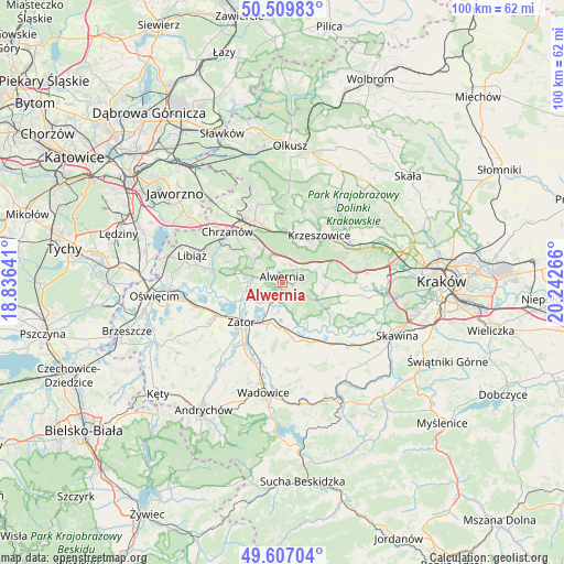
Alwernia GPS coordinates[2]
50° 3' 38.016" North, 19° 32' 22.308" East
| Map corner | latitude | longitude |
|---|---|---|
| Upper-left | 50.50983°, | 18.83641° |
| Center: | 50.06056°, | 19.53953° |
| Lower-right: | 49.60704°, | 20.24266° |
| Map W x H: | 100.4×100.4 km | = 62.4×62.4mi |
| max Lat: | 54.83135° ⇑79.6% North |
| Alwernia: | 50.06056° |
| min Lat: | ⇓20.4% South 49.21328° |
| min Long | Alwernia | max Long |
| 14.20249° | 19.53953° | 24.03723° |
| W 49.6%⇐ | ⇒50.4% E |
Elevation
Elevation of Alwernia is 276 m = 906 ft, and this is 84.6 m = 278 ft above average elevation for this country.
| Max E: |
974 m = 3196 ft | 17.9% |
| Alwernia | 276 m 906 ft | |
| Avg. | 191.4 m = 628 ft | |
Min E: |
-3 m = -10 ft | 82.1% |
See also: Poland elevation on elevation.city.
Geographical zone
Alwernia is located in North temperate zone (between Tropic of Cancer and the Arctic Circle). Distance of this North polar circle is 1835 km =1140.2 mi to North.| Distance of | km | miles | from Alwernia |
|---|---|---|---|
| North Pole | 4440.8 | 2759.4 | to North |
| Arctic Circle | 1835 | 1140.2 | to North |
| Tropic Cancer | 2960.3 | 1839.4 | to South |
| Equator | 5566.2 | 3458.7 | to South |


Nearby cities:
15 places around Alwernia: (largest is in red/bold)
• Babice
6.5 km =4 mi,  278°
278°
• Bolęcin
7.6 km =4.7 mi,  326°
326°
• Brodła
4 km =2.5 mi,  118°
118°
• Grojec
3.5 km =2.2 mi,  21°
21°
• Jankowice
7.2 km =4.5 mi,  255°
255°
• Kamień
6.3 km =3.9 mi,  148°
148°
• Kwaczała
3.4 km =2.1 mi, 276°
• Okleśna
3.3 km =2.1 mi,  190°
190°
• Olszyny
6.3 km =3.9 mi, 262°
• Płaza
6.9 km =4.3 mi,  309°
309°
• Regulice
2.6 km =1.6 mi,  341°
341°
• Rozkochów
3.9 km =2.4 mi,  243°
243°
• Rudno
5.1 km =3.2 mi,  31°
31°
• Spytkowice
7.4 km =4.6 mi,  195°
195°
• Zalas
6.2 km =3.9 mi,  69°
69°
Sources, notices
• [Note1] Compared only with cities in Poland existing in our database
• [Src1] Map data: © OpenStreetMap contributors (CC-BY-SA)
• [Src2] Other city data from geonames.org with taken over terms of usage.
• [Src3] Geographical zone / Annual Mean Temperature by Robert A. Rohde @ Wikipedia
