Tarnówka geodata
Tarnówka (Greater Poland) is a populated place; located in Poland in Europe/Warsaw (GMT+2) time zone. With population of 1,300 people, there are 2055 cities with bigger population in this country. Compared to other cities in Poland, 87.9% of cities are located further ↓South; 86.6% of cities are located further →East and 69.8% of cities have higher elevation than Tarnówka. Note1


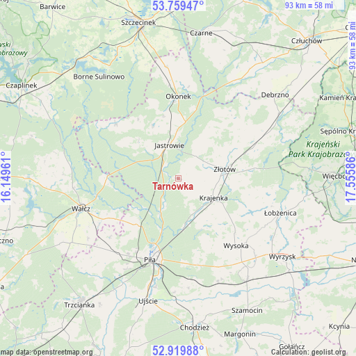
Tarnówka GPS coordinates[2]
53° 20' 30.264" North, 16° 51' 9.828" East
| Map corner | latitude | longitude |
|---|---|---|
| Upper-left | 53.75947°, | 16.14961° |
| Center: | 53.34174°, | 16.85273° |
| Lower-right: | 52.91988°, | 17.55586° |
| Map W x H: | 93.4×93.4 km | = 58×58mi |
| max Lat: | 54.83135° ⇑12.1% North |
| Tarnówka: | 53.34174° |
| min Lat: | ⇓87.9% South 49.21328° |
| min Long | Tarnówka | max Long |
| 14.20249° | 16.85273° | 24.03723° |
| W 13.4%⇐ | ⇒86.6% E |
Elevation
Elevation of Tarnówka is 121 m = 397 ft, and this is 70.4 m = 231 ft below average elevation for this country.
| Max E: |
974 m = 3196 ft | 69.8% |
| Avg. | 191.4 m = 628 ft | |
| Tarnówka | 121 m = 397 ft | |
Min E: |
-3 m = -10 ft | 30.2% |
See also: Poland elevation on elevation.city.
Geographical zone
Tarnówka is located in North temperate zone (between Tropic of Cancer and the Arctic Circle). Distance of this North polar circle is 1470.1 km =913.5 mi to North.| Distance of | km | miles | from Tarnówka |
|---|---|---|---|
| North Pole | 4076 | 2532.7 | to North |
| Arctic Circle | 1470.1 | 913.5 | to North |
| Tropic Cancer | 3325.1 | 2066.1 | to South |
| Equator | 5931 | 3685.4 | to South |


Nearby cities:
15 places around Tarnówka: (largest is in red/bold)
• Jastrowie
9.1 km =5.7 mi,  345°
345°
• Kaczory
26.6 km =16.5 mi,  175°
175°
• Krajenka
10.4 km =6.5 mi,  118°
118°
• Lędyczek
22.9 km =14.2 mi,  18°
18°
• Okonek
21.6 km =13.4 mi,  359°
359°
• Piła
22.5 km =14 mi,  199°
199°
• Skrzatusz
23.7 km =14.7 mi,  229°
229°
• Sypniewo
21.6 km =13.4 mi,  310°
310°
• Szydłowo
25.6 km =15.9 mi,  218°
218°
• Wałcz
26.3 km =16.3 mi,  254°
254°
• Wysoka
23.6 km =14.7 mi,  139°
139°
• Zakrzewo
21.5 km =13.4 mi,  68°
68°
• Złotów
12.7 km =7.9 mi,  79°
79°
• Łobżenica
28.2 km =17.5 mi,  108°
108°
• Śmiłowo
23.3 km =14.5 mi,  168°
168°
Sources, notices
• [Note1] Compared only with cities in Poland existing in our database
• [Src1] Map data: © OpenStreetMap contributors (CC-BY-SA)
• [Src2] Other city data from geonames.org with taken over terms of usage.
• [Src3] Geographical zone / Annual Mean Temperature by Robert A. Rohde @ Wikipedia
