Okonek geodata
Okonek (Greater Poland) is a seat of a third-order administrative division; located in Poland in Europe/Warsaw (GMT+2) time zone. With population of 3,833 people, there are 850 cities with bigger population in this country. Compared to other cities in Poland, 90% of cities are located further ↓South; 86.7% of cities are located further →East and 67.4% of cities have higher elevation than Okonek. Note1


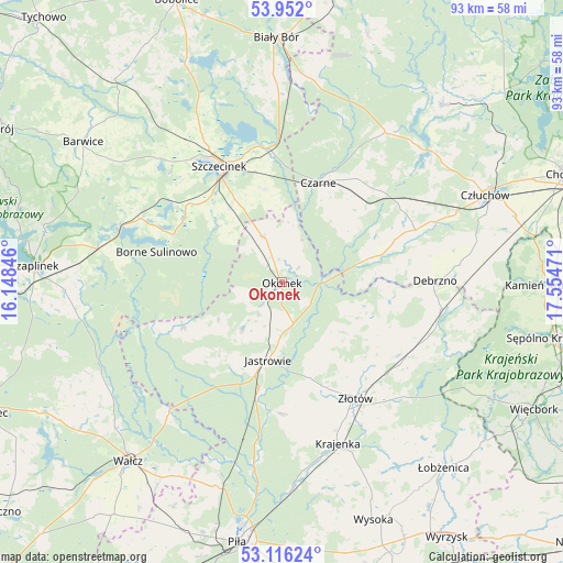
Okonek GPS coordinates[2]
53° 32' 10.248" North, 16° 51' 5.688" East
| Map corner | latitude | longitude |
|---|---|---|
| Upper-left | 53.952°, | 16.14846° |
| Center: | 53.53618°, | 16.85158° |
| Lower-right: | 53.11624°, | 17.55471° |
| Map W x H: | 92.9×92.9 km | = 57.7×57.7mi |
| max Lat: | 54.83135° ⇑10% North |
| Okonek: | 53.53618° |
| min Lat: | ⇓90% South 49.21328° |
| min Long | Okonek | max Long |
| 14.20249° | 16.85158° | 24.03723° |
| W 13.3%⇐ | ⇒86.7% E |
Elevation
Elevation of Okonek is 127 m = 417 ft, and this is 64.4 m = 211 ft below average elevation for this country.
| Max E: |
974 m = 3196 ft | 67.4% |
| Avg. | 191.4 m = 628 ft | |
| Okonek | 127 m = 417 ft | |
Min E: |
-3 m = -10 ft | 32.6% |
See also: Poland elevation on elevation.city.
Geographical zone
Okonek is located in North temperate zone (between Tropic of Cancer and the Arctic Circle). Distance of this North polar circle is 1448.5 km =900.1 mi to North.| Distance of | km | miles | from Okonek |
|---|---|---|---|
| North Pole | 4054.4 | 2519.3 | to North |
| Arctic Circle | 1448.5 | 900.1 | to North |
| Tropic Cancer | 3346.7 | 2079.5 | to South |
| Equator | 5952.7 | 3698.8 | to South |


Nearby cities:
15 places around Okonek: (largest is in red/bold)
• Borne Sulinowo
21.5 km =13.4 mi,  282°
282°
• Czarne
17.4 km =10.8 mi,  19°
19°
• Debrzno
25.4 km =15.8 mi,  89°
89°
• Jastrowie
13.1 km =8.1 mi,  189°
189°
• Krajenka
28.1 km =17.5 mi,  160°
160°
• Lipka
26.8 km =16.7 mi,  99°
99°
• Lędyczek
7.3 km =4.5 mi, 89°
• Rzeczenica
29.9 km =18.6 mi,  34°
34°
• Sitno
18.3 km =11.4 mi,  317°
317°
• Sypniewo
17.9 km =11.1 mi,  245°
245°
• Szczecinek
21.6 km =13.4 mi,  332°
332°
• Tarnówka
21.6 km =13.4 mi,  179°
179°
• Zakrzewo
24.4 km =15.2 mi,  124°
124°
• Złotów
22.9 km =14.2 mi,  146°
146°
• Żółtnica
15.6 km =9.7 mi,  349°
349°
Sources, notices
• [Note1] Compared only with cities in Poland existing in our database
• [Src1] Map data: © OpenStreetMap contributors (CC-BY-SA)
• [Src2] Other city data from geonames.org with taken over terms of usage.
• [Src3] Geographical zone / Annual Mean Temperature by Robert A. Rohde @ Wikipedia
