Jastrowie geodata
Jastrowie (Greater Poland) is a seat of a third-order administrative division; located in Poland in Europe/Warsaw (GMT+2) time zone. With population of 8,452 people, there are 496 cities with bigger population in this country. Compared to other cities in Poland, 88.8% of cities are located further ↓South; 87.1% of cities are located further →East and 81.2% of cities have higher elevation than Jastrowie. Note1


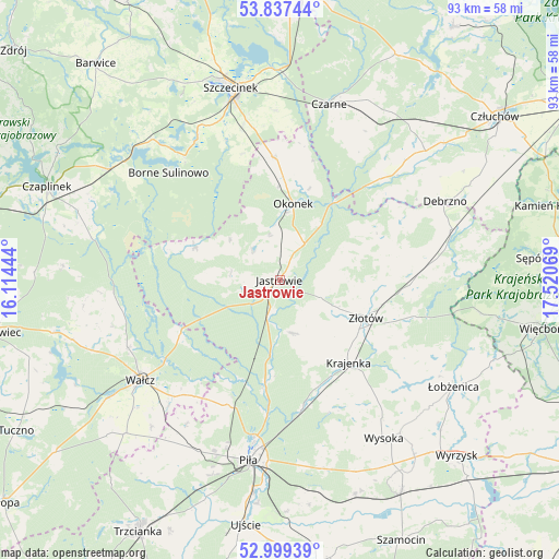
Jastrowie GPS coordinates[2]
53° 25' 13.728" North, 16° 49' 3.216" East
| Map corner | latitude | longitude |
|---|---|---|
| Upper-left | 53.83744°, | 16.11444° |
| Center: | 53.42048°, | 16.81756° |
| Lower-right: | 52.99939°, | 17.52069° |
| Map W x H: | 93.2×93.2 km | = 57.9×57.9mi |
| max Lat: | 54.83135° ⇑11.2% North |
| Jastrowie: | 53.42048° |
| min Lat: | ⇓88.8% South 49.21328° |
| min Long | Jastrowie | max Long |
| 14.20249° | 16.81756° | 24.03723° |
| W 12.9%⇐ | ⇒87.1% E |
Elevation
Elevation of Jastrowie is 97 m = 318 ft, and this is 94.4 m = 310 ft below average elevation for this country.
| Max E: |
974 m = 3196 ft | 81.2% |
| Avg. | 191.4 m = 628 ft | |
| Jastrowie | 97 m = 318 ft | |
Min E: |
-3 m = -10 ft | 18.8% |
See also: Poland elevation on elevation.city.
Geographical zone
Jastrowie is located in North temperate zone (between Tropic of Cancer and the Arctic Circle). Distance of this North polar circle is 1461.4 km =908.1 mi to North.| Distance of | km | miles | from Jastrowie |
|---|---|---|---|
| North Pole | 4067.3 | 2527.3 | to North |
| Arctic Circle | 1461.4 | 908.1 | to North |
| Tropic Cancer | 3333.9 | 2071.6 | to South |
| Equator | 5939.8 | 3690.8 | to South |


Nearby cities:
15 places around Jastrowie: (largest is in red/bold)
• Borne Sulinowo
25.6 km =15.9 mi,  312°
312°
• Czarne
30.4 km =18.9 mi,  15°
15°
• Krajenka
17.9 km =11.1 mi,  139°
139°
• Lipka
29.9 km =18.6 mi,  73°
73°
• Lędyczek
16.1 km =10 mi,  36°
36°
• Okonek
13.1 km =8.1 mi,  9°
9°
• Piła
30.4 km =18.9 mi,  190°
190°
• Sitno
28.2 km =17.5 mi,  339°
339°
• Skrzatusz
28.7 km =17.8 mi,  213°
213°
• Sypniewo
15 km =9.3 mi,  290°
290°
• Tarnówka
9.1 km =5.7 mi,  165°
165°
• Wałcz
27.9 km =17.3 mi,  235°
235°
• Zakrzewo
22.4 km =13.9 mi,  92°
92°
• Złotów
16.1 km =10 mi,  113°
113°
• Żółtnica
28.2 km =17.5 mi,  358°
358°
Sources, notices
• [Note1] Compared only with cities in Poland existing in our database
• [Src1] Map data: © OpenStreetMap contributors (CC-BY-SA)
• [Src2] Other city data from geonames.org with taken over terms of usage.
• [Src3] Geographical zone / Annual Mean Temperature by Robert A. Rohde @ Wikipedia
