Złotów geodata
Złotów (Greater Poland) is a seat of a third-order administrative division; located in Poland in Europe/Warsaw (GMT+2) time zone. With population of 18,395 people, there are 267 cities with bigger population in this country. Compared to other cities in Poland, 88.2% of cities are located further ↓South; 84.1% of cities are located further →East and 73.5% of cities have higher elevation than Złotów. Note1


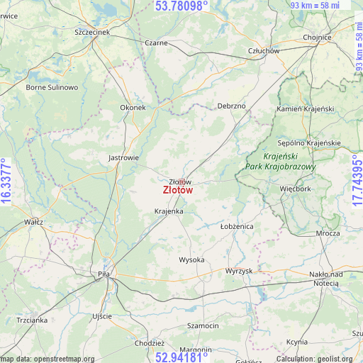
Złotów GPS coordinates[2]
53° 21' 48.456" North, 17° 2' 26.952" East
| Map corner | latitude | longitude |
|---|---|---|
| Upper-left | 53.78098°, | 16.3377° |
| Center: | 53.36346°, | 17.04082° |
| Lower-right: | 52.94181°, | 17.74395° |
| Map W x H: | 93.3×93.3 km | = 58×58mi |
| max Lat: | 54.83135° ⇑11.8% North |
| Złotów: | 53.36346° |
| min Lat: | ⇓88.2% South 49.21328° |
| min Long | Złotów | max Long |
| 14.20249° | 17.04082° | 24.03723° |
| W 15.9%⇐ | ⇒84.1% E |
Elevation
Elevation of Złotów is 114 m = 374 ft, and this is 77.4 m = 254 ft below average elevation for this country.
| Max E: |
974 m = 3196 ft | 73.5% |
| Avg. | 191.4 m = 628 ft | |
| Złotów | 114 m = 374 ft | |
Min E: |
-3 m = -10 ft | 26.5% |
See also: Poland elevation on elevation.city.
Geographical zone
Złotów is located in North temperate zone (between Tropic of Cancer and the Arctic Circle). Distance of this North polar circle is 1467.7 km =912 mi to North.| Distance of | km | miles | from Złotów |
|---|---|---|---|
| North Pole | 4073.6 | 2531.2 | to North |
| Arctic Circle | 1467.7 | 912 | to North |
| Tropic Cancer | 3327.5 | 2067.6 | to South |
| Equator | 5933.5 | 3686.9 | to South |


Nearby cities:
15 places around Złotów: (largest is in red/bold)
• Białośliwie
29.3 km =18.2 mi,  168°
168°
• Debrzno
23.3 km =14.5 mi,  33°
33°
• Jastrowie
16.1 km =10 mi,  293°
293°
• Krajenka
8 km =5 mi,  204°
204°
• Lipka
20.3 km =12.6 mi,  43°
43°
• Lędyczek
19.9 km =12.4 mi,  344°
344°
• Miasteczko Krajeńskie
29.6 km =18.4 mi,  184°
184°
• Okonek
22.9 km =14.2 mi,  326°
326°
• Sypniewo
19 km =11.8 mi,  87°
87°
• Tarnówka
12.7 km =7.9 mi,  259°
259°
• Wyrzysk
27.9 km =17.3 mi,  147°
147°
• Wysoka
20.5 km =12.7 mi, 172°
• Zakrzewo
9.3 km =5.8 mi,  54°
54°
• Łobżenica
18.2 km =11.3 mi,  128°
128°
• Śmiłowo
26.5 km =16.5 mi, 197°
Sources, notices
• [Note1] Compared only with cities in Poland existing in our database
• [Src1] Map data: © OpenStreetMap contributors (CC-BY-SA)
• [Src2] Other city data from geonames.org with taken over terms of usage.
• [Src3] Geographical zone / Annual Mean Temperature by Robert A. Rohde @ Wikipedia
