Wałcz geodata
Wałcz (West Pomerania) is a seat of a third-order administrative division; located in Poland in Europe/Warsaw (GMT+2) time zone. With population of 25,971 people, there are 189 cities with bigger population in this country. Compared to other cities in Poland, 87.2% of cities are located further ↓South; 89.7% of cities are located further →East and 74.5% of cities have higher elevation than Wałcz. Note1


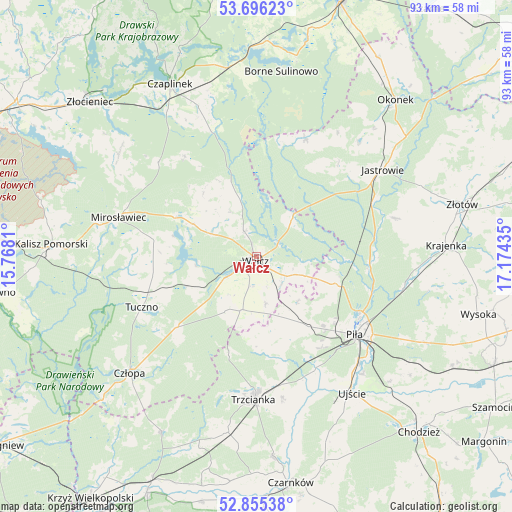
Wałcz GPS coordinates[2]
53° 16' 40.332" North, 16° 28' 16.392" East
| Map corner | latitude | longitude |
|---|---|---|
| Upper-left | 53.69623°, | 15.7681° |
| Center: | 53.27787°, | 16.47122° |
| Lower-right: | 52.85538°, | 17.17435° |
| Map W x H: | 93.5×93.5 km | = 58.1×58.1mi |
| max Lat: | 54.83135° ⇑12.8% North |
| Wałcz: | 53.27787° |
| min Lat: | ⇓87.2% South 49.21328° |
| min Long | Wałcz | max Long |
| 14.20249° | 16.47122° | 24.03723° |
| W 10.3%⇐ | ⇒89.7% E |
Elevation
Elevation of Wałcz is 112 m = 367 ft, and this is 79.4 m = 260 ft below average elevation for this country.
| Max E: |
974 m = 3196 ft | 74.5% |
| Avg. | 191.4 m = 628 ft | |
| Wałcz | 112 m = 367 ft | |
Min E: |
-3 m = -10 ft | 25.5% |
See also: Poland elevation on elevation.city.
Geographical zone
Wałcz is located in North temperate zone (between Tropic of Cancer and the Arctic Circle). Distance of this North polar circle is 1477.2 km =917.9 mi to North.| Distance of | km | miles | from Wałcz |
|---|---|---|---|
| North Pole | 4083.1 | 2537.1 | to North |
| Arctic Circle | 1477.2 | 917.9 | to North |
| Tropic Cancer | 3318 | 2061.7 | to South |
| Equator | 5923.9 | 3680.9 | to South |


Nearby cities:
15 places around Wałcz: (largest is in red/bold)
• Borne Sulinowo
33.5 km =20.8 mi,  7°
7°
• Człopa
31.4 km =19.5 mi,  227°
227°
• Jastrowie
27.9 km =17.3 mi,  55°
55°
• Kaczory
33.5 km =20.8 mi,  125°
125°
• Mirosławiec
26.4 km =16.4 mi,  285°
285°
• Piła
22.6 km =14 mi, 128°
• Siedlisko
32.9 km =20.4 mi,  189°
189°
• Skrzatusz
11 km =6.8 mi,  138°
138°
• Sypniewo
23 km =14.3 mi,  22°
22°
• Szydłowo
15.9 km =9.9 mi, 143°
• Tarnówka
26.3 km =16.3 mi,  74°
74°
• Trzcianka
26.4 km =16.4 mi,  182°
182°
• Tuczno
23.1 km =14.4 mi,  246°
246°
• Ujście
30.4 km =18.9 mi,  145°
145°
• Wierzchowo
31.9 km =19.8 mi,  309°
309°
Sources, notices
• [Note1] Compared only with cities in Poland existing in our database
• [Src1] Map data: © OpenStreetMap contributors (CC-BY-SA)
• [Src2] Other city data from geonames.org with taken over terms of usage.
• [Src3] Geographical zone / Annual Mean Temperature by Robert A. Rohde @ Wikipedia
